July 31st - July looks to end with a bang; will August begin with a whimper?
Overview:
Things look to be setting up for active day. A combination of clear skies this morning, precipitable water values of approximately 1.5 inches, and some dynamic lift from the disturbance that enhanced activity over the weekend all portend widespread thunderstorms across Tucson today and hopefully into the Phoenix metro later this evening and tonight. CAPE values of 1500 J/kg in combination with an unusual veering wind profile could facilitate severe storms developing as well. A question for today is will we break our streak of 100+ F days, which will depend on the timing of convection this afternoon. Things should quiet down after today although how quiet exactly is still up in the air. Flow will become southwesterly after the system lifts north of Arizona tonight, which should allow for some gradual drying to occur. However, there should still be close to climatological values of moisture tomorrow. The more significant issue for tomorrow will be the potential for an inversion to develop just below 500 hPa, potentially serving as a "cap" to potential convection.
Current Conditions:
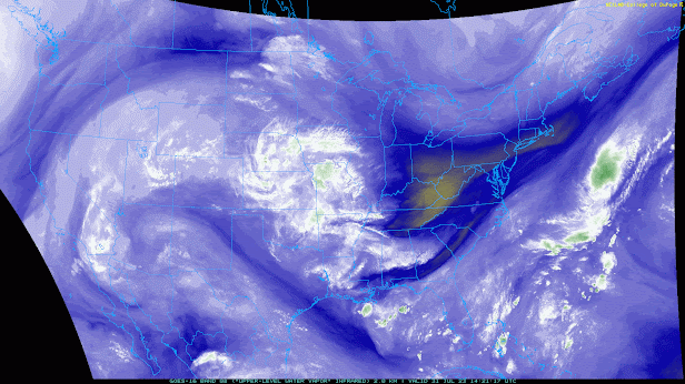
Water vapor imager from this morning shows plenty of moisture throughout most of the Southwest and California. The flow in the western United States is dominated by a strong ridge of high pressure with the inverted trough that has been propagating westward across Mexico evident near the Baja Peninsula.
14Z Water Vapor Image (weather.cod.edu)
This details of the flow are better illustrated by the 500 hPa map from the GFS.
12Z GFS initial analysis
Here you can see the cyclonic disturbance which is forecast to move northward today on the western side of the high-pressure system now centered over the Texas and Oklahoma panhandles. I have highlighted two trough axes within the broader cyclonic circulation with dashed lines. The trough that is further south should rotate northwards towards Arizona today and serve as mechanism to enhance ascent over southern Arizona.
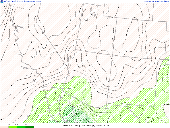
Plenty of moisture is in place as indicated by the GOES derived precipitable water image.
14Z GOES derived PWTR (weather.cod.edu)
Values of precipitable water are approximately 1.5" around the major metropolitan areas, with higher values to the west. Conditions in extreme eastern Arizona have moistened relative to their values over the past several days, indicating that we may not have such a clearly delineated boundary in activity along the Pima/Cochise County border today.
Meanwhile, the visible satellite imagery shows remnants of the overnight convection in California, but rapid clearing into Tucson and most of southeastern Arizona.
14Z Visible Satellite (weather.cod.edu)
The sounding this morning shows only moderate lapse rates as compared to the past few days as convection has acted to bring the lapse rates closer to moist adiabatic.
14Z TUS sounding (spc.noaa.gov)
However, any reduction in instability from the lapse rates, is compensated by the unusually deep moist layer stretching from the surface to above 700 hPa. Modest CINH this morning should disappear this afternoon as temps climb into the upper 90's. Afternoon CAPE values from modifying the sounding of approximately 1500 J/kg should provide potential for severe convection. DCAPE values of about 1000 J/kg should increase this afternoon as we develop the classic inverted "V" structure. Relatively uniform flow this morning from the southeast should veer to the south this afternoon as the 500 hPa trough axis approaches the region.Forecast for Today:
Both the RR and HRRR initializations of the UA_WRF have a good representation of the precipitable water field. However, the 12Z RR initialization looks to be somewhat overdone on this morning's cloud cover.
12Z UA_WRF RR OLR at 7:30 AM MST
This image shows cloud cover as of 7:30 AM MST this morning after skies had already cleared. Based on this, I will use the HRRR initialization, although ultimately differences in the forecast are not significant.
Most iterations of the model forecast show initiation occurring in the 2-4 PM MST time frame. Near surface convergence develops by about 1:30 PM MST between southwesterlies in central Pima County and southerlies in eastern Pima count along the Cochise County border.
12Z UA_WRF HRRR PWTR/wind at 1:30 PM MST
With upper-level flow at this time from the south, the southward facing slopes of the Catalinas may be particularly susceptible to heavy rainfall amounts.
The sounding out of Tucson at this time indicates CAPE values of about 700 J/kg
12Z UA_WRF HRRR sounding valid at 2PM MST
which would argue against a more significant severe threat. This might in part be due to the early initiation time. However, increasing mid-level flow and PWTR values of over 1.6" indicate the potential for some very heavy rains. Additionally, evaporation potential indicates the potential for some heavy winds.
As the afternoon progresses, a significant outflow boundary should propagate northward into Pinal County. This is best illustrated here in the pwtr and wind field.
This outflow will be supported by the widespread nature of convection as well as the storm steering currents. This should continue to propagate the convection northwestward.
12Z UA_WRF HRRR reflectivity at 4:30 PM MST
Note that I do not assume that the timing and evolution of the convection is entirely accurate, but I do think that early and widespread initial convection will propagate to the NW over the course of the afternoon/evening.
By sunset, this should be working its way into Maricopa County and the Phoenix metro area.
12Z UA_WRF HRRR PWTR and wind at 7:00 PM MST
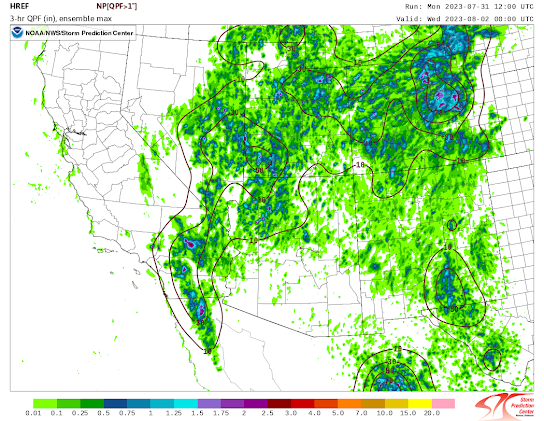
My overall take on the event is that this is likely to be the most widespread event relative to the main population centers that we have seen so far this year. The probability of convection is high, and there are significant positive anomalies of precipitable water over a large area. My inkling is that heavy rain/flooding is likely the most significant widespread threat, and the HREF probabilities of amounts greater than an inch are the best we've seen this season.
12Z HREF max precip and prob >1" valid at 7PM MST
With the coverage of convection, I think that widespread gusty winds are likely, but with only isolated instances of severe thresholds being met. There is a 90% chance for most of the greater Tucson area to experience 30 knot winds, but only the most severe ensemble members are showing winds exceeding 50 knots. However, such a widespread event can still be problematic, especially with places still recovering from Friday's storm.
12Z HREF max wind and prob >30 knots valid at 7PM MST
Tomorrow:
Tomorrow should be a much quieter day. As the disturbance continues to move northward, winds in western Arizona should become southwesterly.
12Z UA_WRF HRRR 500 hPa flow at 3 PM MST Aug 1st.
However, the ridge centered over Texas is keeping southerlies or southeasterlies anchored over extreme eastern Arizona. Consequently, while we will see a reduction if precipitable water, that reduction will be gradual with values likely near or slightly below climatology.
The inversion has the appearance of an elevated subsidence inversion. Also, the fact that this inversion is not far above the LCL, severely inhibits any ability to generate significant updrafts. While the strength of this inversion varies from model to model, it is a general feature as indicated by the HREF precipitation coverage/probabilities.


.png)


Comments
Post a Comment