Posts

Showing posts from March, 2024

March 24th, 2024: Windy, Cold, and Showery Sunday

Image
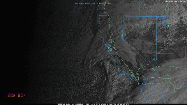
  Synopsis The primary vort max and associated cold front has moved east into New Mexico this morning leaving behind a cold and marginally unstable airmass across AZ. Enough instability will remain in place through this evening for scattered convective showers and an isolated thunderstorm or two across the state. Additional rainfall and snowfall amounts will be highly variable and dependent on trajectory of showers. Expect anywhere between a trace to 0.25 inch of rainfall in the valleys with between 0.10 and 0.50 inches over the higher terrain. Snow levels will remain above 5000 feet with anywhere between a dusting to 6 inches of additional snowfall in the mountains. Current Conditions   Visible satellite imagery and GLM data indicating scattered convective showers and isolated thunderstorms across AZ this morning. GOES-16 visible satellite imagery overlaid with GLM flashes at 9:00AM MST courtesy of College of Dupage. The vort max which provided AZ with moderate to heavy showers and is

March 23rd, 2024: Cold, Wet, and Windy Tonight through Tomorrow Morning

Image
Synopsis A vort max within a broad upper level trough  will impact AZ later this evening into tomorrow morning bringing breezy west winds, low elevation rain, and high elevation snow. CAMs suggest some weak instability tonight so a few thunderstorms are possible as well. Rainfall amounts will be relatively light with only a few hundredths of an inch to 0.25 inch across lower elevations and between 0.25 inch and 1 inch over the higher terrain with the highest amounts along the southwestern/western facing slopes of the mountains through tomorrow morning. Snow levels will remain above 5000 feet, so expect anywhere between a trace to 6 inches between 5000 and 7000 feet and between 6 and 12 inches above 7000 feet with highest amounts expected over the tallest peaks of the White Mountains and Mogollon Rim. Current Conditions At 11:50AM MST, visible satellite imagery displayed a stream of mid and high clouds over AZ and a band of showers moving into Southern California. GOES-16 visible satell

March 14th, 2024: Chances for Valley Rain, Mountain Snow, and Thunderstorms Tonight and Tomorrow

Image
  Synopsis A closed upper level low will deepen over the Desert Southwest bringing a chance for low elevation rain and mountain snow tonight through tomorrow night. Rainfall amounts will be highly variable and range from between 0.1 and 0.5 inches across the lower deserts and between 0.5 and 1.50 inches over the higher terrain. Snow levels will remain above 5000 feet with anywhere between 1 and 6 inches between 5000 and 7000 feet, and 12 to 24 inches above 7000 feet with highest amounts mainly over the mountains of Northern AZ.  CAMs also suggesting some modest instability promoting a chance for a few thunderstorms across the region. Thunderstorms could produce lightning strikes, gusty winds, locally   heavy rainfall, and even small hail.   Current Conditions  At 11:00AM MST, visible satellite imagery displayed an upper level low over the Northern Lower Colorado River Basin, a shallow cumulus field across SE AZ, and broken mid and high clouds across Central and Northern AZ. Visible sat

March 6th, 2024: Chance for Valley Rain and Mountain Snow Thursday

Image
  Synopsis A relatively weak Pacific Storm is expected to impact Arizona tomorrow bringing a chance of mainly light valley rain showers and high elevation snow. Marginal instability will promote a chance for an isolated low-topped thunderstorm or two as well. Rainfall amounts will range from a few hundredths of an inch to 1/3 inch across the lower deserts and between 0.1 and 0.5 inch over the higher terrain with highest amounts along the southwestern/western facing mountain slopes. Snow levels will remain above 6500 feet with 3 to 6 inches of accumulated snowfall with locally higher amounts possible mainly over the highest peaks of the Mogollon Rim and White Mountains.    Current Conditions GOES-18 visible satellite imagery and GLM flashes this morning displays a mid latitude cyclone just west of Point Conception, and a stream of thick high clouds across Arizona. GOES-18 visible imagery overlaid with GLM flashes courtesy of College of Dupage. This stream of high clouds is associated wi