Aug 12th - Quiet Sunday with increasing moisture and activity on Monday
Overview:
Moisture levels have decreased since yesterday which should keep instability in check for most of the greater Tucson area. Convection today should largely be limited to an axis of higher precipitable water situated from southwest to northeast across central Pima County. Some convection is also possible along the higher terrain to the northeast of Tucson. Moisture levels should increase tomorrow as the upper-level low over California shift westward allowing the upper-level ridge to build back into New Mexico. This should shift the 500 hPa flow over southeastern Arizona from southwesterly to southeasterly, allowing for some moisture advection into the region from Mexico. Additionally, upper-level disturbances embedded in the southeasterly flow could enhance convective coverage, although the timing of these disturbances relative to peak heating times may be an issue.
Today:
The sounding from Tucson is unavailable this morning so I will be referencing the sounding from Phoenix.
12Z PHX Sounding (spc.noaa.gov)
Precipitable water values this morning continue to decline from their peak 48 hrs ago. Values at Phoenix are close to climatological norms, but supplementary data from GOES
16Z Vis Sat and GOES PWTR (weather.cod.edu)
as well as the mesoanalysis
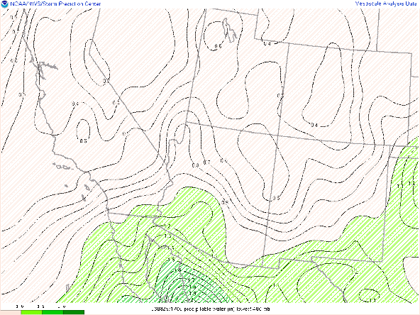
16Z Mesoanalysis PWTR (spc.noaa.gov)
indicate that PW values in the Tucson area are an 1" or less. Surface dewpoints this morning are running in the upper 50's as compared to the lower 60's from the last few mornings. On the positive side of the equation, lapse rates have steepened and are now generally greater than 7 C/km both in the PHX sounding above as well as the mesoanalysis...
While there seems to be some issue with data availability today, we can use the HREF ensemble to see that instability peaks in the early afternoon in parts of central Pima County
presumably as convection decays in the face of decreasing instability. Overall, prospects for convection in the Tucson metro today appear very limited.
With the increasing moisture and steeper lapse rates still in place, instability will be on the rise in eastern Pima county with a 40-60% chance of CAPE values exceeding 500 J/kg.
Which leads a corresponding increase in the probability of heavy precipitation running from eastern Pima into Cochise County.
I also suspect that we will see increasing potential for gusty winds, but without reliable current or forecast soundings from Tucson, I do not feel confident in assessing the potential for DCAPE until more data is available.


.png)


Comments
Post a Comment