Posts

Showing posts from February, 2024

February 28th, 2024: Quick Update for Today's Forecast

Image
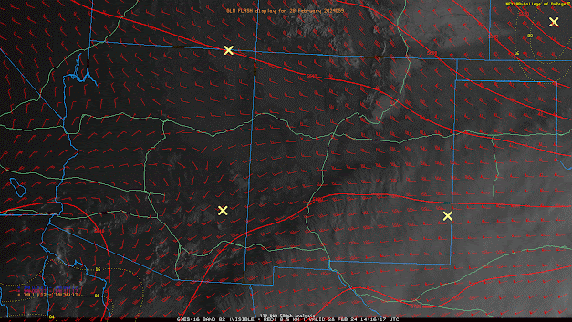
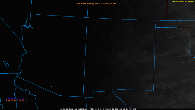
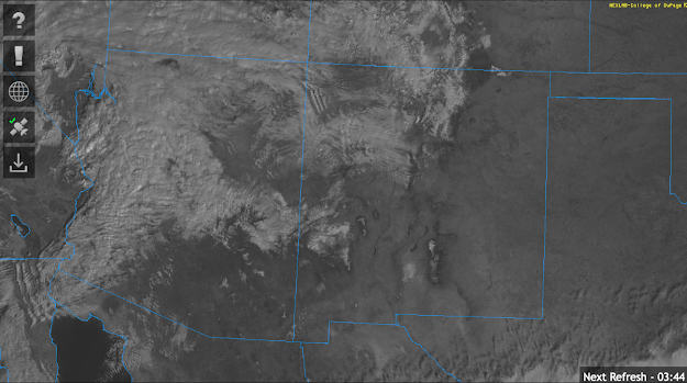
  Synopsis A relatively busy weather day is in store for Southern AZ as a closed low moves through the region bringing widespread convective showers and a few thunderstorms. Main impacts will be brief, locally heavy rainfall, occasional lightning strikes, and gusty winds.   Current Conditions The aforementioned closed low is knocking on the door and currently centered over the far Northern Gulf of CA this morning as indicated by visible imagery overlaid with SPC 500mb analysis.  Visible imagery overlaid with GLM flashes and SPC 500mb RAP Analysis this morning. Scattered cumulus are also noted on this morning's visible imagery with a few showers and thunderstorms over the far Northern Gulf of CA.  This morning's 12z TUS sounding displayed 0.55in of pwat, around 100J/kg of MUCAPE, and decent shear (77 knots) from the surface to 8km. 12z TUS Sounding courtesy of the SPC.   Today's Update Synoptics are on track with no changes needed. As the closed low approaches late this morn

February 27th, 2024: Elevated Showers and Even a Few Thunderstorms Tomorrow Afternoon and Evening Across Southern AZ

Image
  Synopsis Mid and high clouds will continue to move eastward throughout the day today with mostly clear skies expected across the majority of AZ by late this afternoon through tomorrow morning. A closed low, currently a few hundred miles west-southwest of San Diego, will move rapidly eastward today and eventually impact Arizona tomorrow. Widespread bands of elevated convective showers and even a few embedded thunderstorms will be possible, mainly across the Southern half of the state. Precipitation amounts will remain mainly light with only a few hundredths to 0.25 in expected across lower elevations with highest amounts expected in Cochise County and over the higher terrain. This is a warmer system, especially for this time of year, so snow levels will remain above 8000 ft with only a few inches of accumulated snowfall expected over the highest peaks of the Sky Islands and the White Mountains.  Current Conditions Visible satellite imagery this morning displayed a rapid moving stream

February 26th, 2024: Scattered Elevated Convection Across Eastern AZ Today

Image
  Synopsis Modest mid and upper level moisture transport and weak ascent in the warm sector ahead of an upper level trough will bring a chance of high-based scattered showers and isolated thunderstorms today. The main threat will be dry lightning strikes and locally gusty downdraft winds leading to an elevated risk of wildfires today.   Current Conditions At 8:35AM MST, visible satellite imagery and lightning detection networks indicating widespread mid and upper level clouds with embedded showers and isolated thunderstorms across Southern Arizona.  GOES-18 visible imagery overlaid with GLM flashes this morning. SPC 300mb analysis this morning displays the subtropical jet stretching across the Southern half of CONUS which is a good indicator of an El NiƱo pattern.  SPC 300mb analysis as of 15:00z this morning. The 12z TUS sounding this morning measuring 0.62 in of pwat, 69 J/kg of MUCAPE, and 494 J/kg of DCAPE. 12z TUS Sounding courtesy of the SPC. At first glance thermodynamics are ve

February 9th, 2024: Colder Storm to Impact Southeastern AZ Tomorrow

Image
  Synopsis An upper level trough will rapidly dig southward into Arizona late tonight into tomorrow bringing another round of precipitation to primarily SE AZ (including Tucson). This system is much colder than the previous storms this week which means much lower snow levels. Current guidance suggests snow levels above 3000 feet, but cannot completely rule out some wet flurries in the Tucson vicinity. Rainfall amounts expected to be between 0.10 and 0.50 inch across valley locations. Snowfall will range between a trace and 3 inches between 3000 and 5000 feet, 3 to 6 inches between 5000 and 7000 feet, and  6 to 12 inches above 7000 feet with greatest amounts over the tallest peaks of the Sky Islands. As the system moves rapidly eastward Sunday morning, a cold airmass will be left in place with morning frost likely across valley floors Sunday through the middle of next week.    Current Conditions SPC 500mb analysis this morning displays a broad trough over the intermountain west.  SPC 50

February 8th, 2024: Compact Shortwave to Impact Arizona Today

Image
  Synopsis A shortwave embedded in the long wave trough pattern will impact Arizona today providing mainly light valley rain, mountain snow, and brisk southwesterly winds with the highest amounts remaining confined to Northern AZ.    Current Conditions At 9:20AM MST, visible satellite imagery displayed a band of light to moderate showers extending across the western third of Arizona moving rapidly eastward.  GOES-16 visible satellite imagery at 9:20AM MST courtesy of College of Dupage. SPC 500mb analysis this morning shows a shortwave trough centered over Southern Nevada and the lower Colorado River  Valley.  SPC 500mb analysis valid at 15:00Z. WPC surface analysis this morning displays a cold front over western AZ which is associated with the band of showers in that region. WPC Surface Analysis valid at 9:42AM MST. Today's Forecast  The aforementioned shortwave over Western AZ/Southern NV will move rapidly eastward throughout the day today providing AZ with PVA inducing synoptic s