July 28th - Inverted trough increases potential for significant Monsoon activity from Saturday through Monday
Overview:
A potentially busy forecast period ahead, particularly for the Saturday through Monday timeframe after a relatively quiet Friday. Today is likely to be similar to yesterday, with any storms that develop in the higher terrain having some difficulty making into the valley. Chances for activity in the immediate Tucson area should increase tomorrow with the potential for earlier initiation as heights in the upper levels start to fall as the trough approaches. On Sunday, the trough should be situated just southeast of the Tucson area, and the focus for heavy rainfall will likely shift to just west of the immediate Tucson area. By Monday, this feature is forecast to turn northward as the upper-level high pressure system that has been plaguing the area shifts eastward, and the steering flow becomes southerly. This should set up one last round of more widespread activity. I should say that the details of the convection forecast will be heavily influenced by the previous day's convection. Consequently, I will be somewhat broad in my discussion for the weekend, and I will update the forecast daily as conditions evolve.
Current Conditions:
16Z water vapor image (weather.cod.edu)
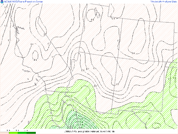
The precipitable water anomaly is shown here to illustrate a couple of points. The first is that a psuedo dry line continues to be situated in extreme southeastern Arizona. This boundary has served as a demarcation line for significant convective activity for the past few days, The second point is that precipitable water values in the vicinity of the inverted trough are still below climatological values. We usually associate these inverted troughs or psuedo "easterly waves" with tropical levels of moisture. However, in this case, persistent subsidence associated with anticyclonic vorticity advection on the east side of the upper-level high, has left the area anomalously dry. While the water vapor imagery above shows the area moistening, the potential for wide-spread excessive rainfall is not as high as we would normally expect given the pressure field.
This morning's sounding indicates less impressive thermodynamics than the past couple of days. The impacts of last night's convection have left the upper levels of the atmosphere with a moist adiabatic lapse rate and somewhat saturated. This is highlight by the cirrus cloud deck present over southeastern Arizona as can be seen here:
While precipitable water values in the sounding are near climatological values at 1.26", the forecast CAPE and DCAPE are about half of the values from yesterday at 401 J/kg and 944 J/kg respectively. While the SPC mesoanalyses, continue to underrepresent precipitable water values in the region by .1-.2", both the 12Z WRF and HRRR initializations of the UAWRF are within 0.04" of the observed value.
Instability is maximized at around 4 PM, although mixed layer and most unstable CAPE values are under a 1000 J/kg. This is about the time that models initiate convection in the higher terrain of the Catalinas and Rincons north and east of Tucson.
Zooming in, we can see the development over the Catalinas, and some of the outflow winds working into the valley, but the reflectivity cores quickly dissipate in a manner similar to yesterday.
with values less than 1000 J/kg, increasing mid-level flow and synoptic-scale conditions favorable for ascent will hopefully lead to storms propagating into the valley.
The wave pattern should become slightly more compact, increasing the forcing for rising motion. Meanwhile, precipitable water values will be approaching 1.75" in western Pima and Yuma Counties.


.png)


Comments
Post a Comment