March 24th, 2024: Windy, Cold, and Showery Sunday
Synopsis
The primary vort max and associated cold front has moved east into New Mexico this morning leaving behind a cold and marginally unstable airmass across AZ. Enough instability will remain in place through this evening for scattered convective showers and an isolated thunderstorm or two across the state. Additional rainfall and snowfall amounts will be highly variable and dependent on trajectory of showers. Expect anywhere between a trace to 0.25 inch of rainfall in the valleys with between 0.10 and 0.50 inches over the higher terrain. Snow levels will remain above 5000 feet with anywhere between a dusting to 6 inches of additional snowfall in the mountains.
Current Conditions
Visible satellite imagery and GLM data indicating scattered convective showers and isolated thunderstorms across AZ this morning.
GOES-16 visible satellite imagery overlaid with GLM flashes at 9:00AM MST courtesy of College of Dupage.
The vort max which provided AZ with moderate to heavy showers and isolated thunderstorms last night is lifting northeast into New Mexico.
 |
| SPC 500mb analysis as of 10:00AM MST this morning. |
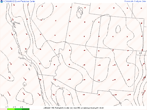
Enough moisture and instability still in place across the region with SPC mesoanalysis indicating pwats between 0.4 and 0.6 inches and SBCAPE between 100 and 500 J/kg.
 |
| SPC mesoanalysis of total precipitable water and 850mb moisture transport as of 10:00AM MST. |
 |
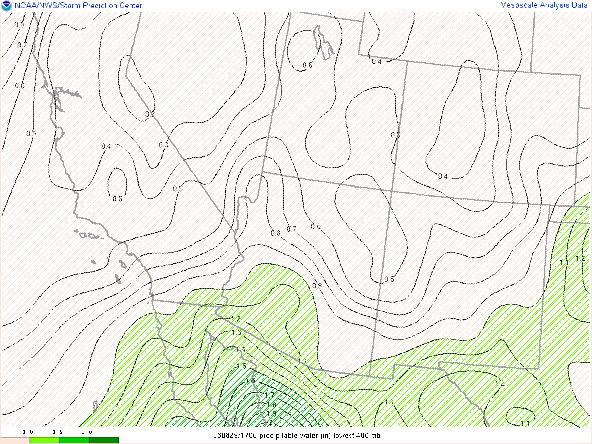
| SPC mesoanalysis of Surface-Based CAPE and CIN as of 10:00AM MST. |
This Afternoon and Evening
Throughout this afternoon and into late this evening, AZ will remain under cyclonic flow aloft as the broad upper level trough remains overhead. However, the primary vort max will move east into New Mexico this afternoon, so there doesn't appear to be any significant embedded shortwave/vort max to move into our region to initiate organized precipitation. Also, throughout the afternoon the long wave trough will move eastward gradually turning steering winds from westerly to northwesterly into this evening.
Based on current CAM solutions this morning, it appears today will be characterized as more of a scattered convective shower day. 12z KPHX and KTUS WRF-HRRR soundings indicating steep low to mid level lapse rates due to cold air aloft with CAPE values in the 100 to 300 J/kg range later this afternoon and early evening.

12z KPHX WRF-HRRR sounding for this afternoon at 3:00PM MST.
 |
| 12z KTUS WRF-HRRR sounding for this afternoon at 3:00PM MST. |
The overall pattern, in my opinion, really favors the Phoenix vicinity this afternoon and early evening. Better thermodynamics in Phoenix with around 300 J/kg of CAPE and around 500 J/kg of DCAPE. Also considering the northwesterly flow by this afternoon, this will allow convection to propagate off the western half of the Mogollon Rim into the Phoenix metro. With decent DCAPE this will also promote the potential for some outflow boundary activity moving off the Rim into Phoenix this afternoon. This idea is supported by the 12z and 15z WRF-HRRR solutions.
12z WRF-HRRR simulated reflectivity for this afternoon at 3:00PM MST.
12z WRF-HRRR simulated reflectivity for this afternoon at 5:00PM MST.
12z WRF-HRRR simulated reflectivity for this afternoon at 7:00PM MST.
Overall, expect scattered convective showers and isolated thunderstorms across AZ today. Any thunderstorm has the potential to produce sporadic lightning strikes/flashes, gusty winds, brief heavy rain, and small hail.
Rainfall amounts will be highly variable and dependent on trajectory and intensity of showers/thunderstorms. Anywhere between a trace and 0.25 inch in the valleys and between 0.10 and 0.50 inches over the higher terrain.
Snow levels will remain above 5000 feet today with anywhere between a dusting to 6 inches can be expected with the highest amounts over the tallest peaks of the Sky Islands, White Mountains, and Mogollon Rim.
Besides precipitation, it will be quite an unpleasant day as it will be cold and blustery across the region. High temps in lower elevations will remain in the 50s and in the 20s and 30s over the mountains. 10 to 25 kt west/northwest winds can also be expected across the lower elevations and between 20 and 40 kts over the higher terrain.


Comments
Post a Comment