Forecast Discussion 06-17-2023
Forecast Discussion for June 17th 2023
Overview: Dry southwesterly flow still dominates most of the Southwestern United States with a weak shortwave/shear zone situated to the west of Arizona. The southern extent of this system is expected to retrograde early next week allowing for the upper-level flow to briefly turn more southerly resulting in some increase in moisture, particularly in the mid-levels of the atmosphere. However, as this happens, temperatures in the middle troposphere will warm limiting instability. Early next week this feature will move eastward through the area resulting in some cloud build ups from the Junteenth holiday into Tuesday, but convection is unlikely. After the system passes, precipitable water is expected to return to significantly below normal levels for the next several days into most of Arizona.
Conditions as of 10 AM: Dewpoints across the region this morning remained fairly low allowing temperatures to drop back in the mid and lower 60's. The surface map indicated surface dewpoints in the teens to mid 30's across southeastern Arizona.
Satellite imagery shows that dry air is not confined to the surface, but extends into much of the lower-troposphere, as indicated by this low-level water vapor image taken from weather.cod.edu.
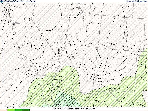
As the southern system retrogresses and becomes more neutrally tilted, the flow will become more southerly and slightly higher precipitable water values will move into the region. The images below are valid at 00Z on the 19th
This image shows satellite derived precipitable water values of less than 10 mm this morning for most of southeastern Arizona (brown colors) also from weather.cod.edu. Note that some higher precipitable water vapor (green colors) are situated in Sanora and California and some of that moisture is may work it's way into our region ahead of an upper-level shortawave.
Model Initializations: All model initializations are in good agreement with placement of moisture and trough axis as verified by current satellite images. While very minor differences exist in the timing and extent of precipitable water increase over the next 24-48h, those differences should not be significant enough to result in differences in sensible weather.
The shortwave feature in question can be seen in the 250 hPa wind field taken from the rapid refresh valid at 13Z this morning. The portion of the trough axis situated near the Baja Peninsula will break separate from the Northern branch and rotrogress, allowing the heights to build over eastern Arizona.
250 hPa Wind
Precipitable Water
This might lead to some mid-level cloud build up as suggested by
the skew T valid at approximately the same time.However, given the exceptionally dry lower troposphere and the lack of instability, precipitation and/or dry lightning are unlikely as indicated by the total accumulated precipitation map taken from the GFS and valid through June 22nd as seen below. (Courtesy tropical tidbits)
Extended Outlook:
Looking ahead into the middle and end of next week, southwesterly flow will reestablish over the Southwest as another deep trough becomes situated west of California and a ridge builds into the Gulf Coast States. The big story for the week will likely be excessive heat through parts of Louisiana and Texas with a continued late onset for our monsoon.


Comments
Post a Comment