Forecast Discussion 07_02_2023
Forecast Discussion 07-02-2023
Overview:
The large-scale picture continues to appear to be on the hot and dry side of the equation. The upper-level high pressure system that has plagued the Southern Plains and the Southwest will continue to be anchored over the area for the next week or more. However, beyond that time frame the situation becomes a little more uncertain. As the position of the upper-level high potentially shifts to the east of the region, upper-level flow may become more southerly. This could allow for poleward moisture surges from the tropical Pacific or from the Gulf of Mexico to work into the area by the first half of next week.
Note there will be a live forecast discussion at 11 AM MST on Wednesday July 5. All are welcome to join this discussion via Zoom at https://arizona.zoom.us/j/5237305771
Some Big Picture Information:
El Nino in full swing
El Nino is in full swing as is shown by the sea surface temperature anomaly map above. El Nino is typically associated with a delayed onset of the Monsoon as the jet stream tends to be displaced southward in western North America. This keeps dryer westerly flow in the area for at least the first half of the Monsoon season. However, the warmer ocean temperatures can lead to a more active Eastern Pacific Hurricane season. That activity, when combined with the more southerly displaced jet stream can lead to significant large precipitation events late in the season associated with tropical cyclone activity.
The Monsoon So Far
Issues related to Heat
The map above gives a pretty good summary of what the weather pattern has looked like for the first part of the Monsoon season and shows the 7 day temperature anomaly ending on July 1st. I have drawn in a mean jet stream pattern consistent with those temperature anomalies. Over the past couple of days, the persistent trough over the western US has weakened and moved eastward, which has allowed for the heat to build back into southern Arizona. This will be especially apparent over the next few days with temperatures expected to be around 110 or higher over the next couple of days.
The following map is a depiction of the 2 meter temperature from the Arizona WRF-RR initialization. The map is valid on Tuesday, but the temperature map for Monday is quite similar.
This heat is associated with the upper-level ridge that has built into the region behind the upper-level trough that briefly cooled our temperatures late last week. The progression of the upper-level heights can be seen in the animation of the 500 hPa normalized height anomalies starting on Friday evening and ending on Tuesday evening.
The lack of moisture.
With the above high-pressure system building in from the Pacific, most of the western portion of the country remains dry as shown in this low-level water vapor imagery from weather.cod.edu.
We can place the current available moisture in a climatological context by using the sounding climatology tool taken from spc.noaa.gov. This figure shows data from every sounding ever taken at Tucson. In this case we are looking at the precipitable water values and the climatology of these values over the course of the year. The lines represent the 0th, 10th, 25th, 50th, 75th, 90th and 100th percentiles respectively from bottom to top. The dot represents the precipitable water value taken from 5 PM MST July 2nd and shows that we are currently near the 10th percentile climatologically.
The 250 hPa flow from the UA-WRF-RR valid for Wednesday shows that the high-pressure system will continue to be anchored either near or just west of Arizona resulting in flow ranging from the northwest to the north-northeast which should continue to keep the are dry for the next few days.
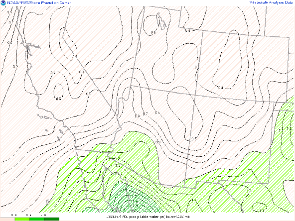
While we still seem very far away from a traditional monsoon pattern, both the ECMWF and the GFS indicate that troughing in the Pacific may displace the high-pressure system to the east, allowing the upper-level flow to become southerly. This should allow an increase in moisture originating from the tropical eastern Pacific by this weekend. The first image shows the 500hPa heights and anomalies valid Saturday morning while the second image shows the precipitable water. In the PW image, I've highlighted values of 1 inch in green as this moisture surges into the Sonoran Desert.


Comments
Post a Comment