Overview:
A number of models continue to show convection in the immediate vicinity of Tucson. The UA_WRF initializations tend to be the most widespread and seem dependent on the northward push of outflow from early convective activity in Sierra Vista County. There is a general consensus among numerical guidance that the atmosphere will dry out somewhat tomorrow leading to a somewhat quieter day. However, the mean ridge position looks to push northward in the mean over the next several days leading to a hopefully more typical Monsoon flow regime, although temperatures are likely to continue several degrees above normal.
Today:
Current Conditions
Sounding from this morning continues to show about 1.5" of precipitable water, which continues values above climatology.
12Z Sounding Some of the more notable aspects of the sounding are 1) A layer from approximately 700-500 hPa with lapse rates of 8.5 C/km, 2) 500 hPa flow out of the east at 20 knots 3) a downdraft CAPE of 1750 J/kg. The downdraft CAPE suggests the potential for some pretty strong downdrafts that could approach severe limits while the 500 hPa flow suggests that we may see some enhanced eastward propagation.
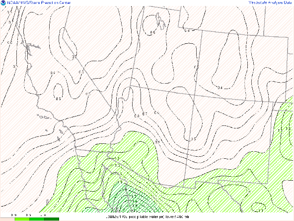
One thing that is interesting to note is that the RAPID REFRESH per the mesoanalyses at SPC as well as the UA_WRF_RR initializations seem to be underdone in terms of the precipitable water content from this morning.
13Z PWTR Mesoanalysis
Note that the mesoanalysis form this morning has precipitable water values of 1.5" confined to parts of western Pima County while the soundings from both Tucson and Phoenix, as well as the GOES derived precipitable water (image below) suggest that those values extend into eastern Pima County.
17Z Vis Sat and PWTR
Based on that misrepresentation, I am going to concentrate on the HRRR based initializations of the UA_WRF forecast for today.
Forecast:
The high-resolution ensembles have the highest probabilities of rainfall that we seen in the immediate Tucson area since Monsoon season began. The image below shows 3 hr QPF accumulations of between 0.1-0.5" in the general vicinity, with about a 30 percent likelihood of accumulations exceeding 1".
12Z HEF 3 hr QPF Valid at 00Z
In addition to the probabilities of rainfall, the ensembles are suggesting a 70% probability of wind speeds exceeding 30 knots, with over 50 knots likely in parts of the area.
12Z HEF Wind Exceedence valid at 00Z
This is consistent with the values of DCAPE that we saw in this morning's sounding and the fact that surface dewpoint depressions should be around 50 F when convection initiates.
The initiation of convection in the UA_WRF is around 2:00 PM MST and initially occurs over Sierra Vista. For brevity, I am only showing the forecast from the 12Z HRRR initialization as the 09Z HRRR initialization looks very similar. I am currently ignoring the RR initialization due to the issue with moisture discussed above.
21Z Reflectivity from UA_WRF
00Z Reflectivity from UA_WRF The evolution shows a convection developing early over the higher terrain of Sierra Vista County which initiates an outflow that propagates northward and eastward, triggering new cells in the vicinity of Tucson by about 00Z. The evolution of this outflow boundary can best be seen in the wind and PWTR fields.
22:30Z PWTR and Wind from UA_WRF
I have highlighted what I presume to be the outflow boundary as a function of a meso-front in the PWTR values as well as the wind field.
22:30Z PWTR and Wind from UA_WRF
One hour later, this outflow boundary has spread and at this point is interacting with the higher terrain of the Catalina and Tucson mountain ranges, initiating new convection. It might very well be that the prospects for convection in the immediate metro area will be dependent on the ability to create significant outflow. The development of convection in Sierra Vista will be a key to watch for in the early afternoon.
Tomorrow:
While a similar flow regime is expected tomorrow, some fairly significant drying of the column is being forecast by both the large scale and mesoscale models, bringing PWTR values down to about an 1", which is somewhat below normal for this time of year. Consequently, I think we can expect a decrease in the amount of activity in the area.
19Z (18th) PWTR and Wind from UA_WRF
12Z HEF 3 hr QPF Valid at 00Z 18th
Rest of the Week:
The rest of the week looks to be a mixed bag of better upper-level and lower available moisture. Favorable combinations of both may be delayed until this weekend or perhaps beyond.
12Z GFS 250 hPa wind Valid at 12Z Thu
12Z GFS PWTR Anom Valid at 12Z Thu


Comments
Post a Comment