August 29th: Hot and Mostly Dry Today
Synopsis
Significantly drier and more stable conditions today leading to minimal convection and very hot temperatures this afternoon and evening.
Current Conditions
High temperatures were brutal across the lower deserts yesterday with Tucson International Airport reporting a max temp of 109 degF, Phoenix Sky Harbor reporting 117 degF, and Yuma Marine Corp Air Base reporting 118 degF. All WRF runs yesterday were forecasting temps a few degrees cooler than what was observed with the raw HRRR having the most accurate high temp forecast.
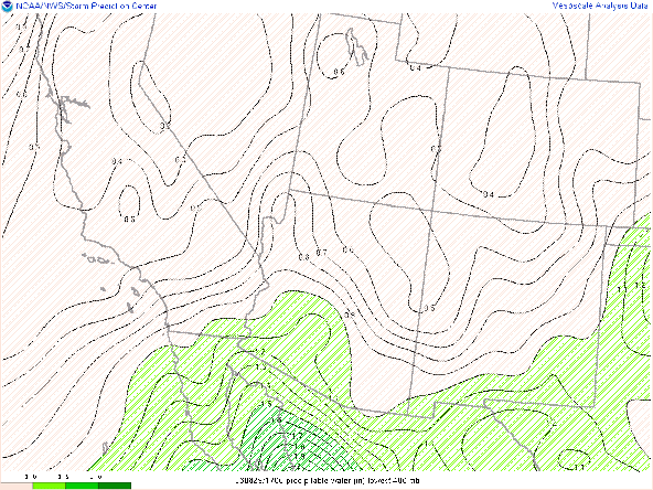
Significant drying has occurred across Arizona with pwats down to around an inch or less via SPC mesoanalysis this morning.
 |
| SPC mesoanalysis of total precipitable water as of 17:00z this morning. |
The mid level anticyclone is currently centered over western AZ with primarily northeasterly winds aloft over much of Arizona.
 |
| SPC 500mb analysis at 17:00z this morning. |
The 12z TUS sounding was depressing with CAPE around 300 J/kg and most importantly a dominant, 4 degC subsidence inversion at 500mb.
 |
| 12z TUS sounding courtesy of the SPC. |
Today's Forecast
Synoptics
The 500mb anticyclone is expected to reach peak strength today with the 12z GFS forecasting the ridge to reach 596dm by early this afternoon.

12z GFS 500mb absolute vorticity for today at 18z.

12z GFS total precipitable water at 18z today.
Thermodynamics
The 12z TUS sounding measured a very stable and relatively dry atmosphere this morning. These thermodynamic conditions will persist into this afternoon and evening across the state with the 12z KTUS WRF-HRRR sounding forecasting a very hostile thermodynamic profile by this afternoon.

12z KTUS WRF-HRRR sounding for today at 5:00 PM MST.
What to Expect
As far as thunderstorms are concerned, don't expect much of anything. In fact, both the 12z and 15z WRF-HRRR runs forecasts nothing more than a few weak, low-topped cells over the highest mountain peaks in Cochise and Santa Cruz counties by late this afternoon. The main focus is the oppressive heat which, considering drier air and a slightly stronger ridge, should provide the region with temps a couple degrees warmer than yesterday. Am favoring the HRRR forecast today since it performed the best yesterday as far as high temps are concerned. The HRRR forecasts temps at or just slightly below 110 degF in the Tucson vicinity with temps between Phoenix and Yuma in the 115 to 118 degF range. I really hate to mention this but, there is a possiblility of some isolated locations in the lower deserts between Phoenix and Yuma to hit 120 degF today.
 |
| 12z HRRR 2-meter temps for today at 3:00 PM MST. |


Comments
Post a Comment