Overview:
By far the biggest story over the next few days will be the continuation of record heat over parts of the Southwest and California. The consistent and excessive heat likely represents a much larger threat to human welfare and power demands than the possibility of convection at least until the weekend. The threat for convection today will be highest to the southeast of Tucson near the international border, although an isolated cell in the higher terrain of the Catalinas and Rincons can't be ruled out. As we move into tomorrow, the focus for activity will likely shift towards that Arizona/New Mexico border as well as portions of Sonora in Mexico.
Today:
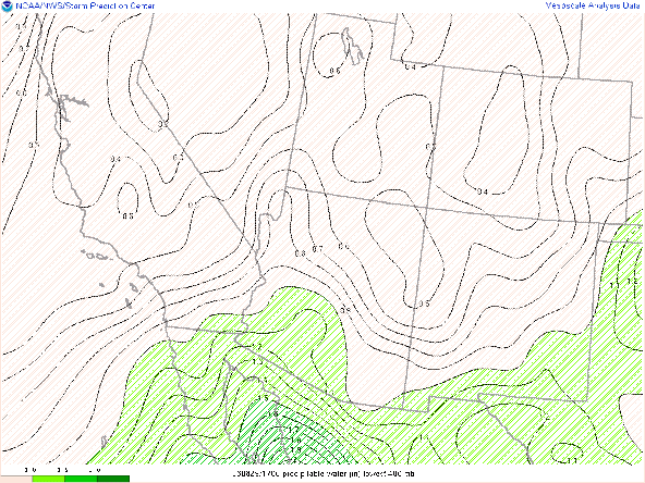
The sounding from 12Z this morning over Tucson shows a somewhat similar story to yesterday. Precipitable water values however continue to exceed expectations/forecasts with a value of 1.3" this morning. However, this moisture appears to be somewhat isolated with a sounding from Phoenix showing only about 1" of water. Additionally. GOES derived PWTR shows values steadily diminishing this morning.
GOES derived PWTR ending at 16:30Z
12Z Tucson Sounding
While the sounding does exhibit some potential for instability, a combination of extremely warm upper-level temperatures and the proximity of the upper-level high pressure system, and the diminishing moisture, limit the likelihood of convection to 20 in the immediate lower elevations to 20 percent or less. Additionally, the muddled wind field indicates that any storms that do form will likely simply "gust out" within time frames of about an hour. By far the bigger concern today will be the excessive heat with 850 hPa temps and 500 hPa heights this morning at or close to all-time highs.
500 hPa height climatology

850hPa Temperature Climo (12Z)
The combination of a near record warm troposphere, in combination with clear skies and relatively low-grade Monsoon possibilities should allow Tucson to set record high temperatures for the next couple of days. The Hi res ensemble means show temperatures easily over 110 for a large swath of southern Arizona. Temperatures in Tucson the next couple of days should be in the low 110's, which should easily best our records of 109 F.
Ensemble Mean Temp Valid 00Z Thursday
One the convection side of the story, the ensembles show the highest threats near the border today. While some wind threat exists with the expected inverted "V" sounding, wind speeds in excess of 40 knots are significantly more likely in Sierra Vista and Parts of Pima County bordering Sonora. Any storms that do develop in the immediate vicinity are still likely to produce gusts in excess of 30 knots.
Ensemble Max winds and Probability of greater than 30 knots
Mean precipitation accumulations are around .1" with a less than 10 percent chance of accumulations of an 1" except for a small portion of Sonora.
Ensemble Mean Precip and Probabilty of greater than 1"
00Z Thursday
As far as the UA_WRF is concerned, GFS initializations continue to exhibit a wet bias and are being discounted. The HRRR initializations, which has a slightly better moisture representation than the RR initialization, does show some convection in the vicinity, but the activity stays south of the I-10 corridor.
UA_WRFHRRR Radar Valid 01Z Thursday
Again, most activity is likely to stay close to the international border.
Outlook for tomorrow:
Things don't look much better for tomorrow as the center of the upper-level high continues to meander over southern Arizona.
GFS 500 hPa Heights and Winds Valid 12Z Thursday
And forecast soundings show precipitable water values dropping to just over 1" with the potential for significant drying of the boundary layer as the day progresses.
UA_WRFHRRR Sounding Valid 12Z Thursday
This drying is borne out by the afternoon sounding, where surface dewpoint temperatures have fallen into the low 40's. Even given a more favorable wind profile above 500 hPa, lifting condensation levels above 600 hPa likely precludes rainfall in the immediate Tucson area.
UA_WRFHRRR Sounding Valid 21:30Z Thursday
Both local and Ensemble guidance shift the focus of attention towards the New Mexico/Arizona border.
UA_WRFHRRR Radar Valid 22Z Thursday
While better upper-level flow may help this propagate eastward, it is likely to dissipate as it moves into the drier surface air.
Ensemble Mean Precip and Probabilty of greater than 1"
With the drier air in place, temperatures should again easily exceed 110 F with portions of California and Arizona approaching 120 F.
Ensemble Mean Temp Valid 00Z Friday
.gif)


.png)


Comments
Post a Comment