July 21st - Conditions should continue to improve through the weekend
Overview:
Upper-level flow and shear patterns are finally favorable for marginally organized convective activity. However, moisture conditions are marginal for today. The NWS discussion made a great point about how the extreme temperatures we have experienced have allowed convective initiation to occur under less-than-ideal moisture conditions. The same should be true today. The limited moisture availability will likely mean a initiation later in the day. However, shear profiles today could mean that any storms may persist past nightfall. Highest probabilities today/tonight will continue to be south and east of the Tucson area, although this activity could work into the metro area after sunset. Moisture conditions should improve tomorrow with more widespread and earlier initiation. Expect convection to fire up both along the Mongollon Rim as well as the higher elevation of Cochise County in the early afternoon. The activity should converge towards the immediate Tucson area as early as the middle of the afternoon.
Today:
12Z Tucson Sounding
The Good: Lapse rates in the 700-500 hPa layer are nearly dry adiabatic at 9C/ km. A rotating wind profile is evident in the 850-500 hPa layer with upwards of 25 knots of shear in that layer. The shear profile should create horizontal vorticity that will interact favorably with westward propagating outflow boundaries for the creation of new updrafts. It may also enhance updrafts in the region of greatest lapse rates.
The Meh: Forecast CAPE and DCAPE values are less than 1000 J/kg and lapse rates above 500 hPa are essentially moist adiabatic.
The Bad: Precipitable water values continue to decrease with just 1.14" available in this morning's sounding. Moisture in the lower boundary decreases rapidly up to about 820 hPa creating the potential for rapid drying of surface dewpoints in the afternoon. Our convective temp continues to be quite high at 108F, although we will likely easily best that mark today.
My Take: Based on the sounding, I think the probability of hazardous convection is somewhat minimal. Of course, with an inverted "V" sounding, gusty outflow winds are always possible, but I would not expect any significant or widespread severe level winds. However, unlike yesterday, I do think that any convection approaching the area from Cochise County has the potential to persist past sunset.
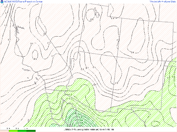
16Z Visible Satellite and PWTR
Sky conditions are clear over the region, setting the stage for another record hot day. The extent of greater than 1.2" of precipitable water has continued to recede to the west.
I have taken the time stamp from the HREF with the most widespread coverage of the greater than 30 knot wind probability in the Southwest. This does highlight the density of coverage is largest south of the border for today, but with a decent cluster of 40 knot winds just south of Tucson. The 03Z time stamp is indicative of the later than normal initiation.
Overenall, I would describe this as a plausible if not exactly probable solution. I do think this type of scenario is how to get convection into the immediate Tucson area, given the overall set up.
12Z GFS 500 hPa Heights-Vorticity Valid at 18Z/22nd
The upper-level high pressure system should continue to shift to the Northwest, resulting in more favorable synoptic-scale conditions.
Convective temperatures should be achieved by the early afternoon when CAPE values are expected to be between 1500-2000 J/kg. I would expect initiation to be well underway by 2 PM along the higher terrain both locally and along the Mogollon Rim. This will set up the possibility for multiple rounds of convection, increasing the threat of heavy precipitation accumulations with ensembles showing a greater than 10% chance of accumulations over an inch in the immediate Tucson vicinity.
There could also be widespread coverage of greater than 40 mph wind gusts with at least a 70% probability of wind speeds exceeding 30 knots.


.png)


Comments
Post a Comment