Overview:
Cloudiness this morning is delaying potential onset today in the immediate Tucson area. Convective initiation in Santa Cruz should still occur as early as 2 PM MST, while the immediate Tucson vicinity will more likely experience initiation in the late afternoon/early evening. Sounding profiles are moister, but with a weaker shear profile hinting at an increased rain threat/decreased wind threat in the immediate Tucson area. Convection could persist into the nighttime hours, particularly in the deserts west of Tucson. Assuming that conditions clear overnight, tomorrow could see more widespread activity with the potential for convection working into the greater Phoenix metro in the evening. A quick peek ahead shows the potential for a brief slowdown of the Monsoon midweek next week as the upper-level high repositions itself near southeastern Arizona.
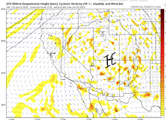
Today:
The upper-level high position is in a climatologically favorable position near the southern border of Utah....
12Z GFS 500 hPa heights and wind valid 00Z/23rd
The sounding from this morning is a little bit of a mixed bag, much like yesterday:
12Z Sounding from TUS
Precipitable water values have increased relative to yesterday to near climatological values. Flow in the troposphere is weak and uniform, suggesting not much dynamic help for propogation or updraft strength. 850-500 hPa lapse rates are still sufficiently steep for some instability, but warming aloft limits the forecast CAPE, with most guidance limiting the CAPE this afternoon at Tucson to around 600 J/kg, although UAWRF guidance produces CAPE values of over 1000 J/kg. Some of this may have to do with forecast 2 m dewpoints in the national HRRR dropping to 40F or less this afternoon. 13Z HRRR 2m Dewpoint valid at 01Z/23rd
Given the moister atmosphere today, and the fact the RR analyses continue to underestimate precipitable water values (see below), I find that level of surface drying suspect, and as a result would not be surprised if CAPE values approached 1000 J/kg this afternoon given that clearing allows temperatures to increase to at least 105 F. 16Z GOES derived PWTR and Vis Sat
16Z RR based PWTR
12Z UAWRF Sounding valid at 01Z/23rd
This sounding from the HRRR initialization seems like a more reasonable depiction of conditions this evening. Much like last night, moist outflows may keep convection firing after dark.
HREF:
The HREF ensembles highlight 1) the possibility of more widespread and heavier rainfall and 2) and evolving wind thread as we go into the overnight hours in south central Pima County.
12Z HREF MEAN precip at 03Z/23rd
There is a 10% chance of precipitation amounts exceeding an inch with heavier downpours likely exceeding .5"
12Z HREF MAX precip at 03Z/23rd
The maximum wind plot shows the largest concentraion of greater than 40 knot winds to the west of the immediate Tucson area.
12Z HREF MAX wind at 03Z/23rd
Expected Evolution
Convective initiation should initially occur in the higher elevations to our south (Santa Cruz) where cloud cover has already cleared out this morning.
12Z UAWRF simulated radar at 2PM MST
Initiation into the Tucson area will likely have to wait until around 6 PM as convergence between the environmental and storm induced wind fields approaches the area.
12Z UAWRF PWTR and surface wind at 6PM MST
The upper-level high will drift eastward towards the four corners region. This will hopefully set the stage for the most widespread convective event of this season.
12Z GFS 500 hPa heights and wind valid 18Z/23rd
Precipitable water values should be near or slightly above climatological averages for most of the area.
12Z UAWRF PWTR and surface wind at 5AM MST/23rd
Instability should be widespread by early afternoon with an axis of higher CAPE extending northward from western Pima County into Maricopa County. 12Z HRRR MUCAPE 1PM MST/23rd
The HREF highlights the widespread potential for convection tomorrow.
12Z HREF MAX wind at 01Z/24th
Guidance indicates a 90% chance of greater than 30 knot winds in Santa Cruz and eastern Pima Counties with the 70% contour stretching up just east of the Phoenix metro. The widepsread precipitation potential is shown here 12Z HREF MAX precip at 00Z/24th
with a 10% chance of greater than an inch of precipitation stretching from the international border up towards Lake Mead. Precipitation amounts appear to be heaviest in a cluster near the international border as well in the higher elevations near Flagstaff.
Potential Issue Next Week:
Ensemble means show the center of the upper-level high (heat dome) is expected to drift back into southeastern Arizona by Wednesday night, This could mean a return to excessive heat conditions in conjunction with a decrease in convective activity.
12Z GEFS 500hPa mean height and anomaly 06Z/27th


.png)

Comments
Post a Comment