Overview:
Considerable left over clouds from storms last night have delayed surface heating and destabilization. As of 9:30 AM clouds were slowly clearing from east to west across the Tucson. Clouds were just clearing the Rincon and Catalina mountains. Temperatures in regions impacted by cloud cover were still generally in the 80's meaning that there is still considerable convective inhibition in place. Unlike previous events, convective initiation is expected to occur locally over the Catalina and Rincon mountains this evening. Similar to yesterday, the clouds this morning have likely delayed the timing of any convection this evening to after 5 PM.
Today:
The satellite picture shows the somewhat problematic cloud cover over the eastern Pima as well as parts of Santa Cruz and Cochise Counties.
Vis Sat 17Z 23rd

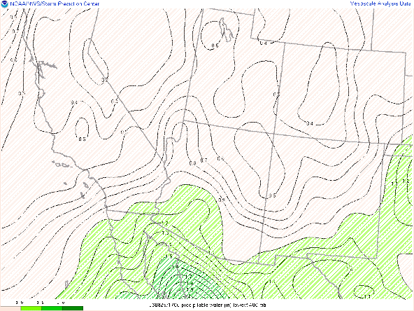
The highlighted areas are the regions of expected convective initiation from earliest to latest across the area. Precipitable water values are near climatology with values ranging from 1.1 to 1.8" from east to west across southern Arizona. As has often been case this season, the Rapid Refresh analysis seems to be a little underdone.
Precipitable Water 17Z 23rd
Values in the analysis are about 0.1" less than soundings and satellite derived values. The satellite derived values are obscured by the cloud cover which is why they are not shown here.
Sounding TUS 12Z/23rd
The sounding from this morning shows a relatively favorable thermodynamic profile. Lapse rates in the lower half of the troposphere average about 8C/km, and moisture profiles suggest that surface dewpoints will not likely drop too much below 50 F in the presence of boundary layer mixing. This issue is the -500 J/kg of convective inhibition, which is made more problematic with the cloud cover this morning. Downdraft CAPES and forecast surface CAPES are likely sufficient to produce a marginal severe threat for winds this evening. This is consistent with the SPC convective outlook for today. Wind profiles are unlikely to support organization of convection and storm motion vectors are likely to be from the east-southeast.
CAPE/CINH at 18Z 23rd
The widespread issue with Convective Inhibition is shown in this analysis. CINH is likely to be overcome in the next couple of hours in the Mogollon Rim but will likely take several more hours of heating elsewhere across the region.
Model Initializations:
I will focus my discussion on initializations of the UA_WRF on cloud cover from this morning as it is likely the most confounding factor to today's forecast.
Most of the model initializations from this morning appear to have underdone this morning's cloud cover except for the 12Z GFS initialization which seems overdone.
12Z UA_WRFGFS OLR Valid at 10 AM MST
12Z UA_WRFHRRR OLR Valid at 10 AM MST
09Z UA_WRFHRRR OLR Valid at 10 AM MSTWith the issues in cloud initialization, it is hard to be completely invested in any particular solution, but I would lean a little more into the GFS solution which is the closest to reality as of 10 AM with the understanding that the GFS runs tend to have a wet bias.
Radar Evolution:
12Z UA_WRFGFS Reflectivity Valid at 1 PM MST
As mentioned above, initiation should be earliest in the Mogollon Rim region where skies have been clear and CINH is minimal. The GFS also starts a cluster in Cochise County unlike most of the other guidance.
12Z UA_WRFGFS Reflectivity Valid at 4 PM MST
By 4 PM, storms are starting to approach northern Pima County with convection also firing up in western Santa Cruz along the Pima County border. In my mind, the most suspect aspect is the line in Western Pinal County.
12Z UA_WRFGFS Reflectivity Valid at 7 PM MST
By 7 PM, storms are shown to be firing along the higher terrain west of Tucson, which I believe is plausible.
HREF:
For completeness, I am including HREF figures here. It is unclear whether initializations of this morning's cloud cover were generally well-handled, but I suspect they were not.
12Z HREF Max 3 hr Precip and Probability >1" 03Z/24th
The ensembles show a relatively large area streching from south central to northwestern Arizona where heavy precipitation is possible, although the southern and northern extents have the highest likelihood of greater than 1" amounts.
Meanwhile, the wind threat map seems to highlight a region of I-10 just northwest of Tucson.
12Z HREF MAX 4 hr Wind and Probability >30 knots 03Z/24th


Comments
Post a Comment