Overview:
Numerical guidance consensus shows that activity will be focused to the west of Tucson today in an axis of higher precipitable water values running from central Pima County northward. Drier air is expected to advect into the area from east to west over the course of the next 48 h, resulting in a pretty quiet day tomorrow. As the week progresses, models indicate that the upper level high will weaken and shift to the east, allowing Tucson to be impacted by one or more significant inverted troughs, which could result in widespread rains and cooler temperatures.
Today:
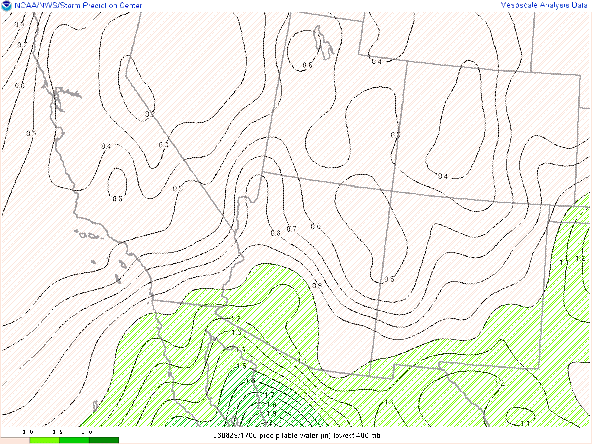
Clear skies dominate the area this morning. Satellite derived Precipitable water values range from around and 1" near the New Mexico border, to more than 1.5 inches from central Pima into Maricopa County. The trend for drier air to advect in from the east is already apparent on satellite imagery this morning.
16Z Visible Satellite Loop with PWTR
The drier air is advecting in on the easterly flow south of the upper-level high situated near ABQ this morning per the upper level Rawinsonde analysis. The strength of this feature continues to be close to the upper bounds of climatological values with 500 hPa heights of 5990 m.
12Z Sounding from Tucson
The sounding from this morning shows higher values of precipitable water than model initializations and Satellite derived quantities indicate. The 12Z HRRR came in with a PWTR value of around an 1" over Tucson, while Satellite derived values were closer to 1.25". By 13Z, HRRR initialized values where closer to satellite derived values. In spite of the large variations in initial PWTR values, most guidance comes into agreement by this afternoon, with PWTR values of around an 1" along the Pima. Cochise County border. Lapse rates are less steep than yesterday with average values of 7.4 C/km in the 850-500 hPa layer. The forecast CAPE of 1360 J/kg this afternoon is unlikely to verify given the drying trends currently noted in satellite imagery. Moderate convective inhibition should erode quickly given the clear skies, and convective initiation in should occur earlier than yesterday. Storm motion should have more of a south to north component today given the southerly 500 hPa flow.
HREF:
The Hi Res ensembles highlight the threat of convection to the immediate west of Tucson today, although given PWTR discrepancies, I would not write off the possibility of convection in the immediate Tucson area.
12Z HREF MAX 3 h precip and prob >1" QPF Valid 00Z/25th
12Z HREF MAX 4 hour wind and prob >30 knots 00Z/25th
The ensembles suggest that the heaviest storms will produce about .75" of precipitation with about a 10% chance of values exceeding an 1". Strongest winds will likely be around 50 mph or just below severe limits, although blowing dust could be a significant problem to the west of Tucson.UAWRF and Prospects for the Tucson Metro
Prospects for the Tucson Metro region are likely dependent either, early initiation along the Catalinas, or the development of a significant outflow boundary developing from convection that is forecast to develop along and west of I-19 early this afternoon. If a significant cluster of storms develops, the resulting outflow boundary could favorably interact with the southwest facing slopes of the Catalinas to initiate new convection.
12Z UA-WRF_HRRR Reflectivity valid at 3 PM MST
12Z UA-WRF_HRRR PWTR/wind valid at 4 PM MST
The outflow boundary depicted in the 12Z WRFHRRR approaches the Tucson metro between 4-5 PM MST and is highlighted by the black line. However, more recent initializations show decreased convective coverage over Santa Cruz and the Todo Odham Nation, which significantly reduces the chance of precipitation over Tucson.
Tomorrow:
Prospects for convection tomorrow seem quite limited as dry air continues to infiltrate the region from the east. This is highlighted by both, the HREF ensemble mean as well as the UA WRF
12Z HREF PWTR valid 00Z 26th
12Z UA-WRF_HRRR PWTR/wind valid at 5 PM MST 25th
The combination of the drier air and lack of clouds, should see temperatures in Tucson rise back to record territory with highs near 110 F.
12Z UA-WRF_HRRR 2m Temp valid at 4 PM MST 25th
With surface dewpoints possibly dropping into the 40s or lower, convective probabilities are uniformly small outside of the immediate international border area.
12Z HREF MAX 3 h precip and prob >1" QPF Valid 00Z/26th
Hope for the future:
Numerous models including the forecasts from ECMWF, GFS, and CMC indicate an anticyclonic wave break resulting in an inverted trough moving westward across Texas and Northern Mexico over the weekend.
12Z ECMWF 500 hPa heights valid at 5 AM Sunday
12Z GFS 500 hPa heights/vort valid at 5 AM Sunday
12Z GEM 500 hPa heights/vort valid at 5 AM Sunday
While differences in the forecast do exist, there is general agreement that a low-pressure system will be near the Baja Penisula with an inverted trough extended northeastward. This should both, provide a moisture surge into the area, while at the same time providing a mechanism for large-scale ascent.


Comments
Post a Comment