July 30: Numerous storms between Phoenix and Yuma by this Evening, More Active in Tucson Tomorrow
Synopsis
Widespread showers and thunderstorms are expected to impact the lower deserts of mainly central and southwestern Arizona this afternoon and evening with a few isolated severe storms possible. Activity will mainly remain west of Tucson today due to drier air advecting from the east throughout the day. Tomorrow looks to be our most active day of the monsoon season with widespread, strong thunderstorms expected across the region (including Tucson and Phoenix).
Current Conditions
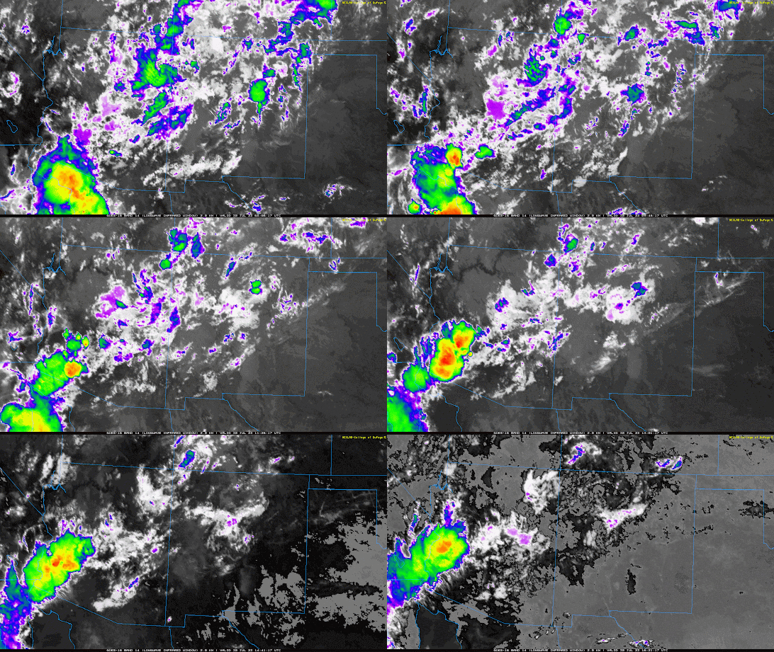
Radar and satellite this morning showed scattered showers and thunderstorms across the lower deserts of western Arizona.
 |
| Infrared Satellite Imagery this morning courtesy of College of Dupage. |
 |
| SPC 500mb Analysis at 16Z. |
 |
| 12z KTUS sounding courtesy of the SPC. |
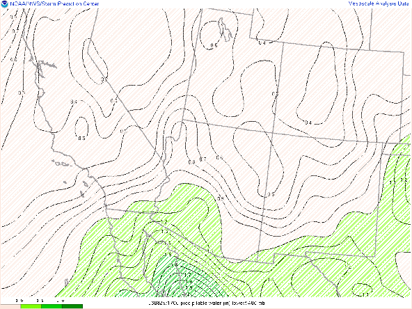
The most interesting feature today is the tight gradient in moisture between southwestern and southeastern Arizona as shown on the SPC mesoanalysis of pwat and observed dew points from the surface observations.
 |
| SPC analysis of total precipitable water as of 16Z. |
Today's Forecast
As of 10:00 AM MST, convection from this morning over the lower Colorado River Valley is beginning to dissipate, and debris clouds are moving northwest into the deserts of southeastern California and southern Nevada. Mostly clear skies are observed across southern Arizona, so plenty of sunshine is expected to aid in convective initiation by early this afternoon.
Southeast Arizona
Favorable thermodynamics from this morning will deteriorate throughout the day across southeastern Arizona as a dry slot over western New Mexico moves into the region. The 12z WRF-HRRR shows a significant decrease in available moisture by late this afternoon with pwats plummeting to below an inch by this evening for most of southeast Arizona (including Tucson)!
12Z WRF-HRRR Total Precipitable Water at 7:30 PM MST.
The 12z KTUS WRF-HRRR sounding forecasts pwat down to 0.97 in, a surface dew point of 41 degF, and almost no CAPE by this evening.
| 12Z KTUS WRF-HRRR sounding at 7:00 PM MST. |
It is interesting to note however that the wrf does have moisture, instability and even some vertical velocity increasing by 8PM MST in Tucson due to outflow from convection to the west of the city moving in which is something to keep an eye on.
| 12Z KTUS WRF-HRRR Model Sounding at 8:00 PM MST. |
With all that being said, am expecting only isolated showers and storms across southeastern Arizona today with most activity occurring mainly early in the afternoon when moisture and instability will be greatest. Also, most activity will occur over the sky islands and near the International border, but a stray cell cannot be ruled out over Tucson.
South-central and Southwest Arizona
The areas of most concern today are the lower deserts north and west of Tucson where much better moisture and instability are expected to remain in place throughout the afternoon. Model soundings forecast sufficient moisture and CAPE as well as decent easterly steering flow for storms to develop between Phoenix and Yuma by this evening.
| 12Z KPHX WRF-HRRR sounding at 8:00 PM MST. |
| 12z KNYL (Yuma) WRF-HRRR sounding at 8:00 PM MST. |
Convection is expected to initiate over the Mogollon Rim and near the International Border in southwestern Pima county by the middle of the afternoon as shown in the 12z WRF-HRRR simulated maximum reflectivity.
12Z WRF-HRRR simulated maximum reflectivity at 4:00 PM MST.
SPC mesoanlysis and observed soundings this morning show DCAPE between 1300 and 1600 J/kg across south-central and southwestern AZ, so strong outflow boundaries from convection near the International Border in Pima County and over the Rim are expected to move through the lower deserts between Phoenix and Yuma by this evening which would initiate new cells in those areas.
12Z WRF-HRRR simulated maximum reflectivity at 8:30 PM MST.
One thing to watch out for this evening is the collision of outflow boundaries between Phoenix and Yuma from convection over Pima county and convection over the Mogollon Rim. The 12Z WRF-HRRR Phoenix metro station plots and simulated reflectivity forecast this scenario.
| 12Z WRF-HRRR phoenix metro station plots and simulated maximum reflectivity at 8:00 PM MST. |
|
By late this evening, thunderstorms will be concentrated mainly in far southwestern Arizona and southeast California along the I8 corridor. Storms will continue moving west into southeastern California before dying off by early tomorrow morning.

12Z WRF-HRRR simulated maximum reflectivity at 12:00 AM MST tomorrow.
Impacts
The SPC has south-central and southwest Arizona under marginal risk for severe weather this afternoon and evening.
Storm Prediction Center Day 1 Outlook.
With DCAPE between 1300 and 1600 J/kg, the primary threat from storms today will be severe wind gusts, but quarter-sized hail from the strongest storms cannot be discounted. HREF 4-hour maximum wind speeds has maximum wind speeds between 50 and 60 knots at 8:00 PM MST in the Phoenix metro, and around 70 knots along the I8 corridor in far southwestern Arizona by midnight.

HREF 4-hour maximum wind speeds at 8:00 PM MST courtesy of the SPC. 
HREF 4-hour maximum wind speeds at 12:00 AM MST (tomorrow) courtesy of the SPC.
Therefore, am expecting the main impacts from the strongest storms today to be strong, damaging winds as well as blowing dust. For anyone traveling along the I8 corridor this evening, hazardous driving conditions (reduced visibility) can be expected.
Flash flooding looks unlikely due to the strong steering flow and the somewhat dry subcloud layer, but isolated flash flooding can never be completely ruled out.
Tomorrow's Forecast
The center of the 500 mb high is expected to be displaced to the east over northern Texas with the inverted trough axis centered over the International Border in southeast Arizona. This feature is forecast to move northward throughout the day tomorrow providing synoptic scale ascent due to positive vorticity advection ahead of the trough.

GFS 500mb Absolute Vorticity for tomorrow at 5:00AM MST.
Moisture is expected to recover overnight tonight across southeastern Arizona with the 12z WRF-HRRR forecasting pwats between 1 and 1.5 inches across the region by tomorrow morning.
12Z WRF-HRRR total precipitable water at 5:00 AM tomorrow.
The KTUS model sounding also reflects a much better thermodynamic profile with 1.55 in of pwat, a surface dew point of 55 degF, and 879 J/kg of MUCAPE by tomorrow afternoon.
| 12Z KTUS WRF-HRRR sounding for tomorrow at 1:00 PM MST. |
Convection is expected to initiate over the high terrain near the International Border as well as the sky islands to the north and east of Tucson by early afternoon tomorrow.
12Z WRF-HRRR simulated maximum reflectivity for tomorrow at 1:30 PM MST.
Outflow from these storms is forecast to move through the Tucson region by the middle of the afternoon leading to numerous thunderstorms across the valley.
12Z WRF-HRRR simulated maximum reflectivity for tomorrow at 3:30 PM MST.
Am going to leave the details of impacts for tomorrow's forecast. In general, we can expect numerous showers and thunderstorms across southeast Arizona tomorrow afternoon with some activity also possible in the Phoenix area by early evening.


Comments
Post a Comment