Aug 9th - Convection focused to the east of Tucson for the next 48 h with a possible return of wider coverage on Friday.
Overview:
Yesterday was an unusual day for Monsoon activity in Tucson as thunderstorm coverage was aided by divergence in the equatorward exit region of a westerly jet streak over northern Arizona. As the shortwave responsible for that jet streak moved east into the Central Plains, shortwave ridging has moved into the intermountain region resulting in a more hostile synoptic-scale environment today. Broad west-southwest flow will persist over the next 24 hours resulting in a drying trend. By Friday however, Tucson should find itself positioned between an upper-level low along the central California coast and an upper-level high over the Gulf Coast. This will result in deep south-southeasterly flow returning with a hopefully corresponding increase in moisture (and convective activity) over the greater Tucson metro area.
Yesterday:
I think it is helpful to discuss the pattern yesterday, to better understand where we find ourselves today.
GFS Analysis 250 hPa winds 5 PM MST Tuesday
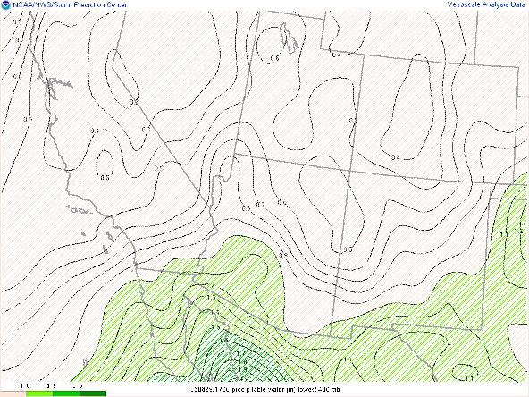
The above jest stream analysis illustrates some of the relevant features from yesterday. The shortwave trough axis is highlighted by the dashed black line. The increased pressure gradient between this trough and the high over the Texas Gulf Coast resulted in a jet entrance region being established over northern Arizona, with upper-level divergence favored over central and southern Arizona. This upper-level divergence was located just north of deep moisture, with precipitable water values of 1.5" or better entrenched in southwestern Arizona.
As of this morning, this trough axis and the associated jet entrance region has shifted east into the Central Plains with an amplified ridge into the Intermountain West. At 500 hPa, Arizona is situated near the ridge axis with west-southwest flow. A feature of note is the upper-level low highlighted off of the Baja peninsula. This feature, in concert with the broad area of high pressure across Texas and Mexico will be the primary influencers of the flow regime over Arizona for the next several days.
GFS forecast 500 hPa vort/winds 11 AM MST Wednesday
In the wake of this ridge axis and westerly flow, precipitable water values should drop later today from values near 1.4" as reported in this morning's sounding. This drop is most pronounced in the mid-afternoon as shown by the UA WRF
UA_WRF HRRR Sounding valid at 3 PM MST Wednesday
UA_WRF HRRR Sounding valid at 4 PM MST Wednesday
Tomorrow:
GFS forecast 500 hPa vort/winds 11 AM MST Thursday
As the upper-level low currently off of the west coast moves northward, mid-level flow should start to turn to the southwest, while southeasterlies become established in Mexico. These southeasterlies should be a precursor to the return of moisture into the area by Friday. Higher values of precipitable water on Thursday will confined to western Arizona, although an axis of higher PW's becomes evident in Mexico, south of the international border.
UA WRF RR PWTR Forecast 11 AM MST Thursday
More widespread activity could return to the area on Friday, as deep southerly flow increases in intensity between the upper-level low situated along the West Coast and Gulf Coast high.
GFS forecast 500 hPa vort/winds 11 AM MST Friday
Embedded in the south-southeasterly flow are numerous vorticity maxima likely associated with the formation of convective complexes over Mexico. While it would be fool hardy to attempt to identify a specific impulse, it is probable that one or more mesoscale vortexes will impact the area on Friday. These features can potentially act as a focus for convective development as well as possible moisture surges into the region. By Friday afternoon, an axis of higher PWTR values should be situated across south central Arizona.
UA WRF RR PWTR Forecast 5 PM MST Thursday
The UA WRF HRRR shows widespread activity by early afternoon, although details on the timing and location will be dependent on the individual features coming out of Mexico.
UA WRF HRRR reflectivity Forecast 4:30 PM MST Friday


Comments
Post a Comment