Aug2 - Thunderstorm chances decrease as excessive heat looks to return to the area by the weekend
Overview:
Moisture should SLOWLY decrease over the next 72 hours as westerlies strengthen into southern California. However, near climatological values of precipitable water will persist for the next 48 h, particularly from Tucson eastward. This will keep thunderstorm chances in the forecast, particularly for the higher elevations of Cochise and Santa Cruz Counties. Any storms that do develop will be dominated by strong outflow as downdraft CAPES should be large as the mid and upper levels of the atmosphere dry out. As 500 hPa heights fall over the West Coast and into the Intermountain West, the 500 hPa ridge currently centered near Oklahoma City should shift southward and expand westward. Combined with the overall drying trend, this should essentially eliminate and chances for convection from Friday into the weekend while heralding the return of record or near record high temperatures.
Current Conditions:
16Z Upper-Level Water Vapor Imagery
Water Vapor imager this morning continues to show highly amplified flow across the contiguous United States with a large ridge of high pressure dominating most of the country. The core of the disturbance associated with the activity over the weekend and into Monday has lifted northward and is indicated by the black "x" while the green lines indicate the dry slot which indicates air with a history of subsidence. This dry slot and associated subsidence inversion created a "CAP" in the atmosphere yesterday preventing the development of any deep convection locally. Remnants of this subsidence inversion are still apparent in the sounding this morning.... (cont. below)
12Z TUS Sounding
just below the 500 hPa layer and highlighted by the orange lines. A second subsidence inversion is apparent near the 300 hPa layer likely associated with the heights building in the wake of the passage of the shortwave noted above. Precipitable water values are still above climatology this morning, with a value of 1.49". The extremely warm morning temperatures aided by some mid-tropospheric cloudiness (see the saturated layer between 500-300hPa) has minimized the development of any convective inhibition. However, the inversions discussed above have resulted in a skinnier CAPE profile, and lapse rates this morning are not particularly steep. Surface heating should essentially eliminate the lower temperature inversion as the day progresses, but associated CAPE increases will be somewhat offset by surface dewpoints dropping into the low 50's by afternoon, and CAPE values are expected to remain less than a 1000 J/kg throughout the day. Wind profiles suggest any storms that develop should propagate to the north-northeast, meaning that any storms that develop along the higher terrain east of Tucson should propagate away from the area.
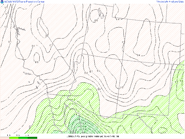
15Z GOES derived precipitable water
Precipitable water values of over an 1" are apparent from the deserts of California through southern Arizona and into Texas. A sharp gradient or dryline does not exist outside of California, and with flow from the south-southwest, eastward progression of the dry air will be slow. Precipitable water values of close to 1.5" are evident in south central Arizona.
Forecast for Today:
12Z UA_WRFRR 500 hPa wind/temp valid at 5 PM MST
The 500 hPa forecast for this evening shows a region of enhanced southwesterlies stretching from Baja, through south central Arizona and up towards Colorado. This band of southwesterlies is also associated with warmer 500 hPa temps and can likely be viewed as a proxy for the dry slot and associated subsidence. This will likely mark the westward boundary for convective activity today and is supported by reflectivity forecasts from the UA WRF
12Z UA_WRFRR simulated reflectivity valid at 5 PM MST
as well as the HREF
12Z HREF max 3hr precip and prob>1" valid at 5 PM MST
Downdraft CAPES are likely to exceed updraft CAPES significantly for any storms that do develop as indicated in the forecast sounding below.
12Z UA_WRFRR forecast sounding valid at 5 PM MST
Forecast for Thursday:
The forecast for Thursday is a little less straightforward than the forecast for today as the flow over southeastern Arizona is a bit muddled.
On the one hand, we have strengthening westerlies encroaching into Arizona, and on the other hand, there is an inverted trough (dashed line) in the easterlies just south of the international border. The end result of these competing air streams will be a sharpening of the moisture gradient across the state
12Z UA_WRFRR PWTR valid at 5 PM MST Thursday
with drier air filtering its way into Tucson by evening
12Z UA_WRFRR forecast sounding valid at 5 PM MST Thu


Comments
Post a Comment