August 14th: Chances for Showers and Thunderstorms Today (mainly in Southeastern Arizona)
Synopsis
Arizona will remain under southeast flow aloft today with precipitable water increasing throughout the day, especially across southeastern and south-central Arizona. A chance of showers and thunderstorms will be possible this afternoon and evening across mainly southeastern Arizona (including Tucson) as well as the White Mountains and Mogollon Rim. Temperatures will remain below excessive heat criteria today as well.
Current Conditions
Visible imagery this morning showed widespread debris clouds across most of Arizona with even a few embedded light showers.

Visible Imagery loop this morning overlaid with GLM flashes courtesy of College of Dupage.
As of 10:00 AM MST, clouds are beginning to clear out in far southeastern Arizona with debris clouds expected to mostly clear out of the region by noon today.
The 12z GFS 500mb analysis this morning displayed the mid level anticyclone centered over central Texas and a cutoff low off the coast of Southern California putting Arizona under southeast flow aloft.

12z GFS 500mb Analysis at 12z this morning.
 |
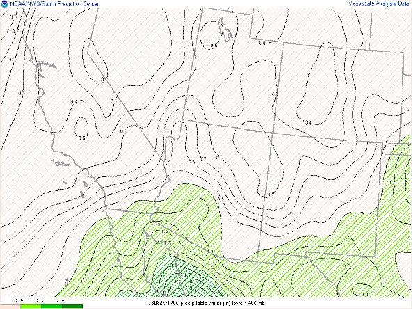
| SPC Mesoanalysis of precipitable water as of 17:00Z this morning. |
Surface Observations as of 10:00 AM MST this morning courtesy of the NWS.
Today's Forecast
Thermodynamics
The 12z TUS sounding was unavailable this morning so have opted to use the 12z WRF-HRRR sounding at initialization.
| 12z KTUS WRF-HRRR sounding at 12z this morning. |
The main factor inhibiting significant convective development today is the lack of instability. Model soundings only forecast CAPE to increase to around 250 J/kg in Tucson by this afternoon which is significantly unfavorable.
| 12z KTUS WRF-HRRR model sounding at 4:00 PM MST this afternoon. |
As the lower levels mix out throughout the afternoon, models forecast DCAPE to reach around 1000 J/kg which will be favorable for strong outflow boundaries.
Moisture is expected to increase throughout the day from the southeast with pwats increasing from around 1.25 in this morning to near 1.50 in this evening.
Synoptics
The 500mb pattern is slightly favorable for large scale ascent today due to a subtle disturbance moving through southeastern Arizona. This disturbance will provide a marginal amount of cyclonic vorticity advection throughout the afternoon.

12z GFS 500mb absolute vorticity at 18z this morning.
What to expect
CAMs continue to advertise scattered showers and thunderstorms across southeastern Arizona (including Tucson) this afternoon and evening. Considering the very weak instability, am expecting the most widespread, intense activity to mainly remain confined to the higher terrain. However with some marginal synoptic scale ascent and sufficient DCAPE for strong outflow boundaries, a few cells could develop in Tucson this afternoon and evening. Am anticipating, just based on poor instability, that most cells will remain low topped, so it's looking like more of a "shower" type setup rather than a thunderstorm setup. Albeit, a few thunderstorms will be possible this afternoon.
Below is the Tucson region station plots to show the evolution of storms in and around the Tucson area this afternoon and evening according to the WRF-HRRR.
| 12z WRF-HRRR Tucson Region Station Plots at 2:00 PM MST. |
| 12z WRF-HRRR Tucson Region Station Plots at 3:00 PM MST. |
| 12z WRF-HRRR Tucson Region Station Plots at 4:00 PM MST. |
| 12z WRF-HRRR Tucson Region Station Plots at 5:00 PM MST. |
| 12z WRF-HRRR Tucson Region Station Plots at 6:00 PM MST. |
| 12z WRF-HRRR Tucson Region Station Plots at 7:00 PM MST. |
| 12z WRF-HRRR Tucson Region Station Plots at 8:00 PM MST. |
| 12z WRF-HRRR Tucson Region Station Plots at 9:00 PM MST. |
With plenty of low level moisture and 500mb heights around 590dm, temperatures will be somewhat mild today with southeast Arizona remaining coolest and the region between Phoenix and Yuma being hottest. Temperatures will remain at or below 100 degF in southeastern AZ today (including Tucson) with temperatures between Phoenix and Yuma between 105 degF and 108 degF.
12z WRF-HRRR 2-meter temps at 3:30 PM MST this afternoon.


Comments
Post a Comment