August 19th: Today's Forecast
Synopsis
The lower deserts of far southwestern AZ and southeastern California are in store for a potentially record breaking event. Hurricane Hillary is expected to continue moving northward today and tomorrow along the coast of the Baja California peninsula where it will weaken to tropical storm strength and make landfall over San Diego. Excessive rainfall, flash flooding, strong winds, and even a couple tornados are likely, mainly west of Yuma through Monday. This discussion will highlight the potential impacts in different regions of Arizona as well as southeastern California for today only.
Current Conditions
Visible imagery overlaid with GOES-17 GLM flashes displayed Hurricane Hillary centered a few hundred kilometers off the coast of southern Baja, mid and high clouds streaming into the southwest, and a few thunderstorms southwest of Yuma in Mexico.

Visible imagery overlaid with GOES-17 GLM flashes courtesy of College of Dupage.
 |
| 12z GFS 300mb analysis at 12z this morning. |
 |
| 12z GFS 500mb analysis at 12z this morning. |
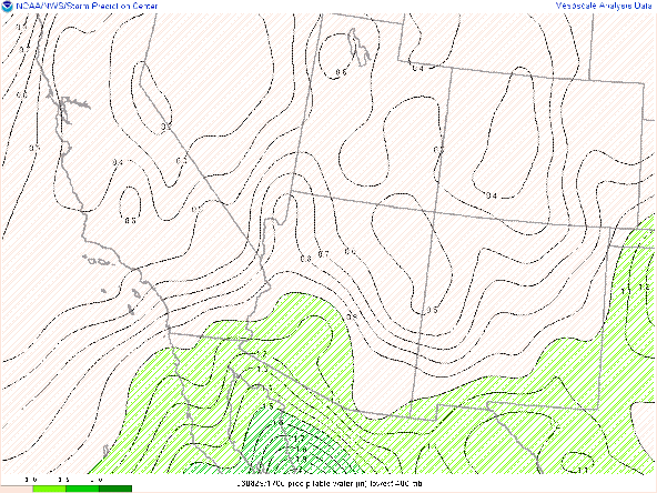
The synoptic scale upper level pattern is causing moisture from Hillary to be transported into the Southwest this morning. Precipitable water has sky-rocketed overnight and the west-east gradient in moisture across Arizona is astounding! SPC Mesoanalysis has 2+ inches of pwat in Yuma county with pwats below an inch in Cochise County! The 850mb moisture transport vector also shows moisture trying to fan out across lower deserts this morning.
 |
| SPC Mesoanalysis of pwat as of 17:00z this morning. |
Today's Forecast
Southeastern and South-Central Arizona (including Tucson and Phoenix)
CAMs are in good agreement that the most widespread activity will remain confined to southwestern AZ today with only a few showers and storms possible east of Gila Bend. The 12z TUS sounding had less than 100J/kg of CAPE, 1.35 in of pwat, and a subtle inversion at 500mb. Somewhat better in Phoenix with the 12z PHX sounding measuring around 300 J/kg of CAPE, pwat of 1.68 in, and no inversion at 500mb.
 |
| 12z TUS sounding courtesy of the SPC. |
 |
| 12z PHX sounding courtesy of the SPC. |
CAMs don't show much activity east of Gila Bend today and into the night due to increasing cloud cover and the development of a strong capping inversion in the mid levels due to warming from condensation. The 12z KTUS WRF-HRRR sounding reflects this scenario with only 153 J/kg of CAPE expected by this afternoon.
| 12z KTUS WRF-HRRR sounding for today at 4:00 PM MST. |
Phoenix is almost identical with the 12z KPHX sounding forecasting identical thermodynamic conditions.
| 12z KPHX WRF-HRRR sounding for today at 4:00 PM MST. |
The only positive is the veering vertical wind profile indicating some weak synoptic scale support today. However, the mid level capping inversion and extensive cloud cover will likely put a lid on any storm development in these areas today. However a few showers and even a brief thunderstorm or two cannot be completely ruled out especially over the highest mountain peaks.
Southwestern AZ and Southeastern CA (including Yuma)
The focus for precip today will mainly be confined to far southwestern AZ and southeastern CA this afternoon, evening, and overnight. A meridional upper level jet is developing across the far southwest of the US stretching from northern Baja into California, western Arizona, and Nevada. This pattern will continue to aid in moisture transport into the southwest today and into tomorrow as Hillary approaches San Diego.
 |
| 12z GFS 300mb winds for today at 18z. |
Southwestern AZ and southeastern CA will remain in a favorable region of synoptic scale ascent due to upper level difluence and upper level divergence associated with the right entrance region of the jet max. Throughout the late afternoon and into the evening moderate to heavy rain is expected to develop in this region as Hillary moves farther north. The Yuma (KNYL) model sounding from the 12z WRF has pwats remaining near 2 inches but only marginal instability with about 300 J/kg of CAPE expected by late this afternoon.
| 12z KNYL WRF-HRRR sounding at 4:00 PM MST today. |
The 12z and 15z WRF-HRRR forecast precipitation increasing significantly after sunset with the Yuma model sounding showing 2.35 in of pwat, a surface dew point of 68 degF, and a saturated (moist adiabatic) column between 700 and 400mb at midnight tonight. Not a whole lot of instability, but sufficient synoptic scale ascent (indicated in the omega profile) and a juicy atmosphere will provide plenty of lift for heavy rainfall in this region overnight into early tomorrow morning.
| 12z KNYL WRF-HRRR sounding for 12:00AM MST tomorrow. |
What I find most impressive is the cyclonic turning of the wind with height reflected in the vertical wind profile and the hodograph.
The 15z WRF-HRRR forecasts total Precipitation in southwestern AZ and southeastern CA to range between 0.5 and 1 inch with locally higher amounts possible dependent on any thunderstorms.
 |
| 15z WRF-HRRR total Precipitation forecast between 15z today and 11z tomorrow. |
The heaviest rain, strongest winds, and best thunderstorm chances will be tomorrow into early Monday morning for southwestern AZ and southeastern CA.


Comments
Post a Comment