August 22nd: Much less Activity Today; Remnant Circulation from Tropical Storm Harold Impacting our Region Starting Tomorrow
Synopsis
Enough moisture and instability today for a few showers and storms across southern Arizona. The best chances for storms will remain mainly west of Tucson and over the sky islands, but a couple showers and storms are possible in Tucson this afternoon and evening. Tropical Storm Harold, currently making landfall in far southern Texas, will continue to move onshore and weaken rapidly throughout the day today. The remnant circulation and moisture associated with it will begin to move through Arizona tomorrow.
Current Conditions
Very active yesterday afternoon and evening with numerous showers and strong thunderstorms impacting the regions between Tucson and Phoenix. 1.5 inch hail was reported at the NWS Tucson office via SPC storm reports. Miraculously, the Phoenix Sky Harbor finally reported measurable precipitation. It wasn't much at all (0.04 in), but I'm sure Phoenix residents are thinking "about damn time." Tucson International Airport received 0.74 in and based on climo Tucson is now slightly above normal for this time of year!
2023 Monsoon Rainfall and Climo Tracker courtesy of NWS Tucson.

SPC 500mb analysis as of 17z this morning.
 |
| 12z TUS sounding courtesy of the SPC. |
Today's Forecast
Synoptics
The area of most favorable synoptic scale ascent will be in northern Arizona where that region will be under the right entrance region of the jet max. Meanwhile in southeastern Arizona, we will be under the influence of anticyclonic vorticity advection as the remnant circulation of Tropical Storm Harold moves rapidly westward toward our region.

12z GFS 500mb absolute vorticity at 5:00 PM MST today.
Thermodynamics
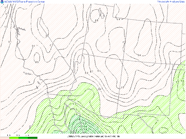
The 12z TUS sounding had a bit of moisture and CAPE, but a whole lot of CIN. Throughout the afternoon, sufficient surface heating should erode that region of CIN. WRF forecasts pwats to hang around an 1 to 1.25 inches today in the Tucson vicinity. The 12z KTUS WRF-HRRR sounding forecasts CAPE to only reach a little over 300 J/kg by late this afternoon with a subsidence inversion above 500mb associated with the anticyclonic vorticity advection.
| 12z KTUS WRF-HRRR sounding for today at 5:00PM MST. |
The caveat is the WRF's significant under-forecast of the surface dew point. The WRF forecast the surface dew point in Tucson to be 50 degF at noon today. Well, as of 12:00 PM MST, surface obs have dew points in the mid 60s still! SPC mesoanalysis has CAPE between 1000 and 1500 J/kg in the Tucson vicinity as of 11:52 AM MST. There is still a couple hundred J/kg of CIN though, but as mentioned above, surface heating throughout this afternoon should erode most of that CIN.
SPC mesoanalysis of CAPE and CIN as of 18:52z this morning.
What to Expect
The synoptics and thermodynamics will be competing today with anticyclonic vorticity advection generating large scale descent, and enough moisture and instability still favorable for storm development. My thinking is conditions will be more on the unfavorable side for storm development today. Even if there is over 1000 J/kg of CAPE, synoptic scale descent will make it very difficult for parcels to be lifted to the LCL and LFC. Notice from the model sounding that the LCL height is expected to be above 700mb and an LFC height close to 600mb. It would take quite a bit of lift to get a parcel to the LCL and LFC and considering the synoptic scale descent, that will be very difficult to achieve. Therefore, only isolated showers and storms will possible in the Tucson vicinity this afternoon and evening with the best chances remaining over the sky islands surrounding Tucson as well as to the south and west of the city. Considering the dry sub cloud layer, any storms could produce localized, gusty winds.
12z WRF-HRRR simulated maximum reflectivity for 2:00 PM MST.
 |
| 12z WRF-HRRR simulated maximum reflectivity for 4:00 PM MST. |
12z WRF-HRRR simulated maximum reflectivity for 7:00 PM MST.
Tomorrow's Forecast
The remnant circulation from Tropical Storm Harold will makes its way into southeastern Arizona beginning late tomorrow morning. This feature will bring cyclonic vorticity advection (synoptic scale ascent), and ample amounts of moisture into the region.
 |
| 12z GFS 500mb absolute vorticity for tomorrow at 18z. |
 |
| 12z WRF-HRRR total precipitable water for tomorrow at 4:00 PM MST. |
| 12z KTUS WRF-HRRR sounding for tomorrow at 2:00 PM MST. |
 |
| 12z WRF-HRRR 10-meter winds for tomorrow at 10:00 AM MST. |


Comments
Post a Comment