August 26th: Chance For a Few Storms in Tucson this Evening with Less Activity Tomorrow; Excessive Heat Conditions Continue
Synopsis
The following discussion will be valid for today and tomorrow.
Moisture and instability will be just sufficient enough for a chance of afternoon and evening storm chances in southeastern Arizona (including Tucson). The mid level anticyclone will continue to build west into Arizona today and tomorrow leading to very warm temperatures across the lower deserts. The high will be centered over Arizona starting tomorrow decreasing storm chances and increasing high temperatures.
Current Conditions
Visible imagery this morning displayed numerous mid level debris clouds across southeastern Arizona.
Visible imagery this morning as of 10:00AM MST courtesy of College of Dupage.
 |
| SPC 500mb analysis as of 17:00z this morning. |
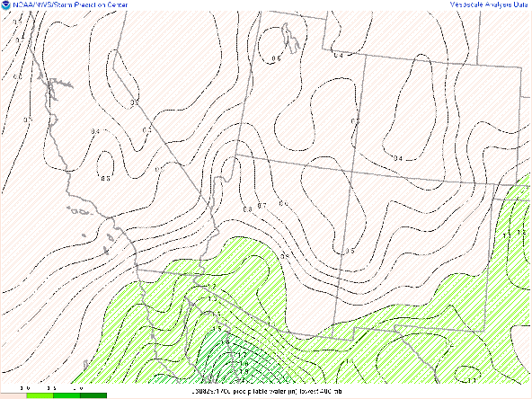
SPC mesoanalysis of total precipitable water as of 17:00z this morning.
 |
| Surface observations as of 17:00z courtesy of the NWS. |
Marginal instability measured on the 12z TUS sounding with just below 500 J/kg of CAPE, and around 1000 J/kg of DCAPE. Also noted is a 3 degC subsidence inversion just above 500mb and over -300 J/kg of CIN.
 |
| 12z TUS sounding courtesy of the SPC. |
Today's Forecast
Synoptics
The 500mb anticyclone will continue to build westward into Arizona starting today which will act to increase mid level heights and therefore lead to warmer temperatures. Mid level flow will remain southerly and weak around 10 knots today which is identical to yesterday. The issue is the subsidence above 500mb which is due to the 250mb high directly over southeastern Arizona.
 |
| 12z GFS 500mb absolute vorticity for today at 5:00 PM MST. |
 |
| 12z GFS 250mb divergence for today at 5:00 PM MST. |
Thermodynamics
Mid level debris clouds are very slowly burning off this morning and are expected to continue burning off over the next few hours. Yesterday at this time, cumulus were already developing over the high terrain, so am thinking a delayed convective initiation today. The 12z WRF-HRRR under forecast the CAPE yesterday afternoon with the 00z TUS sounding measuring around 800 J/kg of CAPE and WRF was forecasting a little over 300 J/kg at that time. This is due to the HRRR's drier boundary layer bias. It appears today will be a repeat of that with the 12z KTUS WRF-HRRR sounding forecasting 351 J/kg by the middle of this afternoon.
 |
| 12z KTUS WRF-HRRR sounding for today at 2:00 PM MST. |
Am thinking this is an underestimation with CAPE likely reaching over 500 J/kg by late this afternoon. The only potential caveat is the duration of cloud cover, so if debris clouds stick around longer than expected there will much less convection today due to limited surface heating. DCAPE will also remain over 1000 J/kg as well again so any storm that develops will be able to produce locally gusty outflow winds and blowing dust.
What to Expect
Another day of ambiguous conditions with the synoptics unfavorable for significant storm development today due to weak steering winds and some subsidence above 500mb. On the other hand, thermodynamics are marginally favorable with pwats between 1.25 and 1.50 in, CAPE likely reaching at or slightly more than 500 J/kg, and DCAPE over 1000 J/kg. The 15z WRF-HRRR is a bit more aggressive with slightly more coverage of storms this evening in Tucson compared to the 12z. There were a few weak cells in the Tucson metro yesterday evening which the 15z WRF-HRRR was forecasting yesterday. Considering this, am leaning toward the 15z solution rather than the 12z solution.
The 15z WRF-HRRR forecasts convection to initiate over Santa Cruz and Cochise counties by the middle of the afternoon.
15z WRF-HRRR simulated maximum reflectivity for today at 3:00 PM MST.
15z WRF-HRRR simulated maximum reflectivity for today at 5:00 PM MST.
15z WRF-HRRR simulated maximum reflectivity for today at 6:00 PM MST.
15z WRF-HRRR simulated maximum reflectivity for today at 7:00 PM MST.
15z WRF-HRRR simulated maximum reflectivity for today at 8:00 PM MST.
The majority of storms today will likely remain lower topped as the subsidence above 500mb will be opposing vertical motion in the upper levels. In general, the majority of storms will remain over the higher terrain and near the International Border with a few cells possible in the Tucson metro by this evening. Can't completely rule out a brief, rogue cell over the Phoenix metro this evening but that chance is very remote at this time.
Temperatures will be a couple degrees warmer today, particularly between Phoenix and Yuma where temps are likely to reach between 108 and 113 degF by this afternoon.
15z WRF-HRRR 2-meter temps for 2:30 PM MST this afternoon.
Tomorrow's Forecast
By tomorrow the 500mb and 250mb anticyclones will be nearly vertically stacked over Arizona which will strengthen subsidence aloft.

12z GFS 500mb absolute vorticity for tomorrow at 5:00 PM MST.
 |
| 12z GFS 250mb divergence for tomorrow at 5:00PM MST. |
Moisture will also decrease, particularly in southeastern AZ, with the 12z and 15z WRF-HRRR forecasting pwats to fall to around 1 inch in Tucson by tomorrow afternoon with pwats remaining around 1.25 and 1.50 in in southwestern and south-central AZ.
12z WRF-HRRR total precipitable water for tomorrow at 5:00 PM MST.
With increasing subsidence and decreasing moisture, thermodynamics will deteriorate with almost no CAPE in Tucson by tomorrow afternoon as indicated by the 12z KTUS WRF-HRRR sounding.
 |
| 12z KTUS WRF-HRRR sounding for tomorrow at 5:00 PM MST. |
12z WRF-HRRR 2-meter temps for tomorrow at 4:30 PM MST.
In general, storm chances will be isolated at best with the greatest chances for any storm over the highest mountain peaks as well as near the International Border in Pima county where just enough moisture and instability will be in place for a brief cell or two to bubble up.


Comments
Post a Comment