August 27th: Quick Update for Today
Synopsis
Still in store for a very hot day across the lower deserts of Arizona due to the center of the mid level anticyclone directly over Arizona today. The update is to address the potential for an isolated storm or two over the Tucson metro late this afternoon and into the early evening hours.
Current Conditions
SPC 500mb analysis displays the mid level anticyclone centered over southeastern Arizona at 594 dm.

SPC 500mb analysis as of 18:00z this morning.
What caught my attention this morning was the 12z TUS sounding which observed a much more impressive thermodynamic profile than I was anticipating for today.
 |
| 12z TUS sounding courtesy of the SPC. |
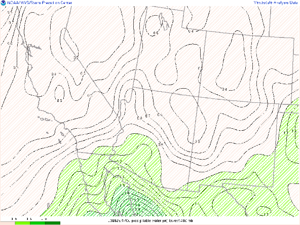
1.64 in of pwat, around 800 J/kg of CAPE, and a surface dew point of 65 degF were measured in Tucson early this morning. SPC mesoanalysis of pwat as of 18:00z shows pwats between 1.1 and 1.50 in across southern Arizona. What appears to be occurring, which CAMs don't seem to be picking up outside of a 24 hour forecast, is the recycling of moisture. Notice that low and mid level flow is very weak (less than 15 knots) which is preventing moisture to be advected out of the region. With weak winds, this moisture is essentially "stuck"or "trapped" in the low and mid levels and will continue to be recycled until strong enough winds can advect drier air into the region.
SPC mesoanalysis of total precipitable water as of 18:00z this morning.
Today's Forecast
Synoptics
The 500mb anticyclone will remain centered over southeastern Arizona throughout the day today leading to hot temperatures and a bit of subsidence above 500mb. Subsidence combined with weak midlevel flow will maintain an unfavorable synoptic environment for storm development today and will likely keep storms isolated, low-topped, and short-lived this afternoon and evening.

12z GFS 500mb absolve vorticity for today at 5:00 PM MST.
Thermodynamics
Similar to yesterday, just enough moisture and instability below 500mb will be sufficient enough for a few showers and storms across southeastern AZ. The 12z WRF-HRRR wasn't even remotely close to initializing with the correct thermodynamic conditions. The 15z WRF-HRRR on the other hand appears to have initialized correctly. The 15z has provided the best solutions the past couple of days so am basing my forecast today on the 15z solution.
The 15z WRF-HRRR has pwats hanging between 1.25 and 1.50 in throughout this afternoon and evening.
15z WRF-HRRR total precipitable water for today at 5:00 PM MST.
Due to strong surface heating, the boundary layer is slowly mixing out with surface dew points down in the upper 50s across the Tucson metro. This also means CAPE is decreasing as SPC mesoanalysis displays CAPE around 500 J/kg in the Tucson vicinity as of 18:00z compared to the 800 J/kg at 12z.
SPC mesoanalysis of SBCAPE as of 18:00z this morning.
The 15z WRF-HRRR forecasts CAPE around 200 to 300 J/kg in the Tucson vicinity by late this afternoon which is far from impressive. Am thinking CAPE will likely be closer to 500 J/kg by this evening which should be just enough to advertise an isolated chance for a brief cell or two in the Tucson metro.
15z WRF-HRRR maximum CAPE for this afternoon at 4:00 PM MST.
What to Expect
I wouldn't expect anything more than a brief, low-topped storm or two over the metro by late this afternoon and early evening. The 15z is advertising this potential as shown below.
15z WRF-HRRR simulated maximum reflectivity for 5:00 PM MST.
 |
| 15z WRF-HRRR simulated maximum reflectivity for 6:00 PM MST. |
In general, most activity will remain over the higher terrain as well as near the International Border, but a couple cells are possible in the Tucson vicinity by late this afternoon and early evening. Storms will be relatively weak and low-topped, due to the hostile environment above 500mb.
No changes to the temperature forecast as temps are still expected to reach around 105 degF in Tucson and the lower deserts between Phoenix and Yuma reaching 110 degF or more by this afternoon.
15z WRF-HRRR 2-meter temps for 3:00 PM MST this afternoon.


Comments
Post a Comment