August 31st: Better Storm Chances and Much Cooler Temps Today and Tomorrow
Synopsis
Better synoptics combined with sufficient moisture and instability will promote a much greater chance for showers and thunderstorms across Arizona today and tomorrow with tomorrow being the most active day. With lower mid level heights and decent low level moisture, high temperatures will be significantly cooler as well.
Current Conditions
A strong thunderstorm cluster impacted the Tucson vicinity yesterday evening with strong winds, blowing dust, and even a bit of rainfall.
NWS 24-hour accumulated precipitation map.
A severe storm over northeast Tucson dropped quarter sized hail via SPC storm reports too.
SPC Hail reports from yesterday.
The mid level anticyclone which has been providing Arizona with extreme heat has finally weakened significantly and is now centered over central New Mexico. This puts Southern Arizona under easterly/southeasterly flow aloft.
 |
| SPC 500mb analysis as of 1700z. |
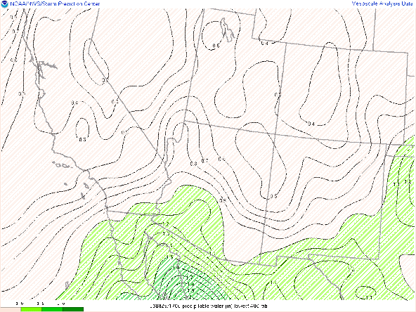
An overnight Gulf of California moisture surge has increased moisture across southwestern and south-central Arizona with pwats between 1.25 in and 1.60 in from Phoenix southwestward. Much drier in southeastern AZ with pwats around 1.20 in in Tucson and decreasing rapidly eastward.
 |
| SPC mesoanalysis of total precipitable water as of 17:00z. |
 |
| 12z TUS sounding courtesy of the SPC. |
Today's Forecast
Synoptics
Much better synoptic conditions today with a weakened mid level anticyclone centered over central New Mexico and 20 to 25 kt mid level southeasterly/easterly flow over southern and Central Arizona. Only a weak bit of subsidence in the 500mb to 400mb layer which should not be an issue for storm development today.
Also, an upper level low currently centered off the west coast of Central Baja will begin to lift northward today and tomorrow which will provide some synoptic scale support. The best synoptic scale ascent will likely be tomorrow (mentioned in tomorrow's forecast section below).
 |
| 12z GFS 2 PVU Pressure Map Courtesy of Tropical Tidbits. |
As this feature approaches Arizona this afternoon and evening, synoptic scale ascent will slowly increase which is evident in the weak mid and upper level veering wind profiles on the 12z KTUS WRF-HRRR model sounding.
 |
| 12z KTUS WRf-HRRR sounding for 3:00 PM MST today. |
Moisture and Thermodynamics
The best moisture will remain in Central and Western Arizona today with southeastern AZ on the drier side. As shown in the pwat map above, there is a very tight zonal gradient in moisture between western AZ and eastern AZ. The 12z WRF-HRRR maintains pwats between 1.1 and 1.25 in in the Tucson vicinity with pwats between 1.25 and 1.50 in for Phoenix westward.
12z WRF-HRRR total precipitable water for today at 3:00 PM MST.
A bit more favorable thermodynamics in Phoenix by this afternoon with the 12z KPHX WRF-HRRR sounding forecasting CAPE around 700 J/kg, DCAPE over 2000 J/kg, and pwat just below 1.50 in.
 |
| 12z KPHX WRF-HRRR sounding for today at 4:00 PM MST. |
What to Expect/Potential Impacts
Both the 12z and 15z WRF-HRRR runs keep most of the widespread, intense activity west of Tucson due to better moisture, instability, and synoptic scale support in that region. However, there will be enough moisture and instability for a chance of storms in the Tucson vicinity this afternoon and evening. All CAM solutions have convection initiating by the middle of the afternoon which seems reasonable considering that the atmosphere is going to need a few hours of insolation to mix out the large amounts of CIN from this morning. The 15z WRF-HRRR has been performing better than the 12z lately so am leaning toward that solution for today's forecast. The 15z WRF-HRRR forecast of the evolution of convection today is shown below.
15z WRF-HRR simulated maximum reflectivity for today at 3:00 PM MST.
15z WRF-HRR simulated maximum reflectivity for today at 5:00 PM MST.
15z WRF-HRR simulated maximum reflectivity for today at 6:00 PM MST.
 |
| 15z WRF-HRR simulated maximum reflectivity for today at 8:00 PM MST. |
15z WRF-HRR simulated maximum reflectivity for today at 10:00 PM MST.
 |
| 15z WRF-HRR simulated maximum reflectivity for tonight at 12:00 AM MST. |
Even though both the 12z and 15z runs keep the majority of storms outside of the major population centers today, it is interesting to note that recent runs of the HRRR (16z and 17z) are hinting at storm clusters making it into the Phoenix metro by late this evening.
 |
| 16z HRRR simulated reflectivity for tonight at 11:00 PM MST courtesy of Tropical Tidbits. |
 |
| 12z WRF-HRRR 2-meter temps for today at 3:30 PM MST. |
 |
| 12z GFS 500mb absolute vorticity for tomorrow at 18z. |
 |
| 12z GFS total precipitable water for tomorrow at 18z. |
 |
| 12z GFS 250mb divergence for tomorrow at 18z. |
 |
| 12z WRF-HRRR total precipitable water for tomorrow at 1:00 PM MST. |
 |
| 12z KTUS WRF-HRRR sounding for tomorrow at 4:00 PM MST. |
 |
| 12z KPHX WRF-HRRR sounding for tomorrow at 5:00 PM MST. |


Comments
Post a Comment