August 3rd: Hot and Abnormally Dry through the Weekend
Synopsis
Isolated showers and thunderstorms are possible this afternoon over the highest mountain peaks in far southeastern Arizona. Friday through the weekend, the 500mb high is forecast to be centered over southeastern Arizona and southwestern New Mexico leading to hot, dry conditions across the region. High temperatures are expected to reach excessive heat criteria in the lower deserts starting Friday and persisting into early next week.
Current Conditions
SPC 500mb analysis at 17:00Z this morning and mid level water vapor imagery displays the 500mb ridge centered over the Texas/Louisiana border and dry, southwesterly flow over the Desert Southwest.

500mb Analysis at 17:00Z courtesy of SPC.

GOES-17 mid level water vapor imagery this morning, courtesy of College of Dupage.
The 12z TUS sounding reflected this synoptic pattern with a strong 4 degC subsidence inversion just below 500mb and a significant dry air mass above this inversion.
 |
| 12z TUS Sounding courtesy of SPC. |
Below 500mb, there is still some marginal amounts of moisture with 1.26 in of pwat and a surface dew point of 56 degF, but instability is severely lacking with only 96 J/kg of MUCAPE, and forecast CAPE only expected to reach around 400 J/kg by this afternoon.
Today's Forecast
With an unfavorable synoptic pattern, a strong midlevel capping inversion, and limited instability, am expecting very minimal storm activity today across far southeastern Arizona. WRF-HRRR, WRF-RR, and WRF-GFS forecast a few, weak cells to develop across Cochise County by this afternoon.
12Z WRF-HRRR simulated maximum reflectivity at 4:30 PM MST.
However, I checked the model soundings from this morning's runs, and all three under-forecast the strength of the capping inversion near 500mb at 12Z as shown below.
12Z KTUS WRF-HRRR model Sounding at 5:00 AM MST.
12Z KTUS WRF-RR model Sounding at 5:00 AM MST.
12Z KTUS WRF-GFS model Sounding at 5:00 AM MST.
With this in mind, am expecting even less coverage than our wrf is forecasting today. However, convergence (due to differential heating of the terrain) over the highest mountain peaks could provide just enough lift for an isolated, low-topped storm to develop by this afternoon, but the strong, mid level capping inversion will put a lid on any updraft attempting to breach the 500mb level.
Also, with the ridge centered well to our east and some low level moisture across Arizona, high temperatures should remain at or below 110 degF in the lower deserts today.
12Z WRF-HRRR 2-meter temps at 4:00 PM MST.
Tomorrow through Sunday
The deterministic GFS and ECMWF as well as their ensemble members are in good agreement regarding the positioning and strength of the mid level ridge for tomorrow through this weekend. The ridge is forecast to build to the west starting tomorrow and become centered at around 592 dm in southeastern Arizona and southwestern New Mexico. The ridge is forecast to strengthen throughout the weekend with heights rising to 598 dm over southern Arizona by Sunday at 18Z.

12Z GFS 500mb heights and vorticity for Friday at 12Z.

12Z GFS 500mb heights and vorticity for Saturday at 12Z.

12Z GFS 500mb heights and vorticity for Sunday at 18Z.
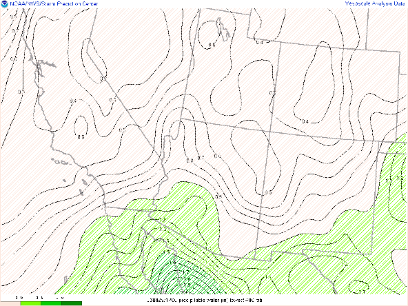
Available moisture is also expected to decrease over the next few days with pwats hovering at or just below an inch Friday through Sunday across southern Arizona.
12Z WRF-GFS total precipitable water for Saturday at 11:00 AM MST.
 |
| 12Z WRF-GFS total precipitable water for Sunday at 11:00 AM MST. |
With decreasing moisture and increasing heights aloft, temperatures are forecast to get hotter and convection will be nearly nonexistent over the next few days. High temperatures are expected to reach excessive heat criteria by tomorrow mainly between Phoenix and Yuma where temps over 110 degF are likely. Tucson should remain a couple degrees below 110 degF tomorrow, but will likely reach 110 degF by Saturday and Sunday.
12Z WRF-GFS 2-meter temps for tomorrow at 4:00 PM MST.
12Z WRF-GFS 2-meter temps for Saturday at 4:00 PM MST.
 |
| 12Z WRF-GFS 2-meter temps for Sunday at 4:00 PM MST. |
Next Week
There are some differences in the deterministic GFS and ECMWF as well as their ensemble members regarding the pattern for next week. Some recent runs of the GFS have been hinting at the 500mb ridge weakening slightly and centering farther to our east opening the door for a slight increase in moisture from the south. The tropical Eastern Pacific is starting to heat up a bit with the NHC forecasting a 70% chance of a disturbance off the west coast of Mexico developing into a tropical cyclone over the next few days.
National Hurricane Center 7-Day Tropical Weather Outlook for the Eastern Pacific.
Will need to monitor this over the next few days to see if moisture from this tropical disturbance will influence our weather here. For now, am expecting dry, hot conditions to continue through early next week with a slight uptick in moisture possible.


Comments
Post a Comment