August 7th: Storm Chances Return Starting Today
Synopsis
Showers and Thunderstorms are expected to increase in intensity and coverage starting today and persisting through the week. With plentiful amounts of low level moisture, temperatures will be much cooler across the region compared to the past few days throughout this week as well, but it will definitely feel very muggy. The main focus for storms today will be in southeastern Arizona as well as over the high terrain in northeastern Arizona this afternoon and evening. Tomorrow, convection is forecast to increase in coverage and intensity as the mid level anticyclone weakens, lowering heights aloft.
Current Conditions
Visible satellite imagery this morning shows a few showers and storms developing over northeastern Arizona and northwestern New Mexico as well as scattered altocumulus debris clouds across southeastern Arizona.
 |
| 12z TUS Sounding courtesy of the SPC. |
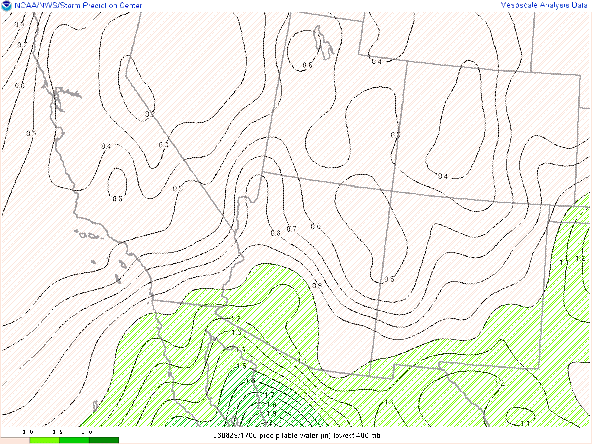
Surface observations this morning measuring dew points in the 60s, and SPC mesoanalysis displaying pwats of 1.3 to 1.7 in across central and southern Arizona.
Surface Observations at 17:00Z this morning courtesy of the NWS. 
SPC analysis of total precipitable water as of 16:00Z this morning.
As far as synoptics are concerned, SPC mesoanalysis displays a weak 300mb jet streak just east of the Four Corners, and the 500mb anticyclone centered over far western Texas.
 |
| SPC 300mb analysis as of 17:00Z this morning. |
 |
| SPC 500mb analysis as of 17:00Z this morning. |
Today's Forecast
Synoptics
The 500mb anticyclone will still remain somewhat strong today with models forecasting 500mb heights around 596 dm into this evening. A high of this strength will most likely lead to delayed convective initiation with most models forecasting storms to begin developing around the early to mid afternoon over the high terrain. Also with the center of the 500mb anticyclone to the south and east of Arizona, steering flow is southwesterly which isn't really an ideal steering flow for monsoonal storms to propagate into the lower deserts.
At 300mb on the other hand, there is a tad bit of synoptic scale ascent due to speed divergence aloft associated with the right entrance region of the jet streak to our northeast. The best synoptic scale ascent will remain mainly in northeastern Arizona and northwestern New Mexico where speed divergence is maximized.
Cloud Cover
As shown in the visible imagery this morning, there are plentiful amounts of mid level clouds across primarily southeastern Arizona. All runs of the WRF maintain this cloud cover across southeastern Arizona into the middle of the afternoon which will act as a lid on convective initiation. There will be some breaks in the mid level cloud deck however so any locations that can receive some sunshine, particularly the higher terrain, storms could develop quite quickly especially considering the ample amounts of moisture and sufficient instability.
Thermodynamics
The 12z TUS sounding had plenty of low level moisture and CAPE. The only issue is that there is still a significant dry layer above 400mb due to dry air being transported from the southwest generating a marginal amount of subsidence in the upper levels. The 12z KTUS WRF-HRRR model sounding has this layer of subsidence increasing throughout the day with a strong inversion developing in the upper levels by this evening.
| 12z KTUS WRF-HRRR sounding at 7:00 PM MST. |
| 12z KTUS WRF-HRRR sounding at 8:00 PM MST. |
What to Expect
Currently, ample amounts of moisture and sufficient instability are working in favor of convective initiation over the high terrain in northeastern and southeastern Arizona by the middle of the afternoon with cloud cover working against convective initiation. The 12z WRF-HRRR, WRF-RR, and WRF-GFS all forecast convection to initiate this afternoon, particularly over the high terrain south and east of Tucson.
12z WRF-HRRR simulated maximum reflectivity at 3:30 PM MST.
12z WRF-HRRR simulated maximum reflectivity at 6:30 PM MST.
By the time outflow boundaries approach the Tucson area, thermodynamics are expected to be significantly less favorable than this morning with CAPE dropping to around 500 J/kg, -381 J/kg of CIN, and a strengthening mid level capping inversion. The 12z WRF-HRRR station plots for the Tucson region seem to reflect this scenario with strong, southeasterly outflow winds pushing through the area but fail to initiate any new storms.
| 12z WRF-HRRR Tucson station plots and simulated reflectivity at 8:00 PM MST. |
| 12z WRF-HRRR Tucson station plots and simulated reflectivity at 9:00 PM MST. |
With all that being said, showers and thunderstorms can be expected primarily south and east of Tucson this afternoon and evening, but an isolated cell or two cannot be ruled out in Tucson this evening. In order for storms to develop in Tucson, either outflow boundaries would need to move through the Tucson region a couple of hours earlier than models are forecasting, or the mid level capping inversion needs to be much weaker than expected.
Regarding high temperatures today, a combination of a moist boundary layer and scattered cloud cover will provide the region with cooler temperatures with Tucson reaching around 100 degF by this afternoon. The lower deserts between Phoenix and Yuma will still reach temps between 105 degF and 110 degF with small fluctuations dependent on the extent and location of cloud cover. Unfortunately, the trade off with cooler temps is the added humidity which will make it feel quite muggy today across the state.
12z WRF-HRRR 2-meter temps for today at 4:00 PM MST.
Tuesday through Friday
On Tuesday the 500mb high weakens and becomes centered near far southwestern Texas. CAMs forecast better storm coverage in Tucson starting tomorrow and increasing Wednesday and Thursday. The GFS and ECMWF also are hinting at a weak inverted trough to move northward on Thursday and Friday which could significantly increase storm coverage across the state. Will have more details regarding Tuesday and Wednesdays forecast tomorrow.


Comments
Post a Comment