September 12th: 2023 Monsoon Farewell Event Day 2
Synopsis
Numerous showers with embedded thunderstorms this morning impacted Southeastern Arizona (including Tucson) with plenty of lightning and heavy rain. Busy day in store for today due to synoptic scale ascent combined with sufficient moisture and instability. The SPC has Central and Southeastern AZ in a marginal risk for severe thunderstorms today with the primary impacts being severe grade wind gusts and 1 inch hail in the strongest storms.
Current Conditions
Quite an active morning with a few rounds of showers and embedded thunderstorms in Pima and Pinal counties associated with a shortwave trough moving through the region overnight into this morning. Current radar and satellite imagery displays a weakening cluster of showers and embedded thunderstorms just northeast of Tucson and this activity will continue to weaken throughout the morning hours.
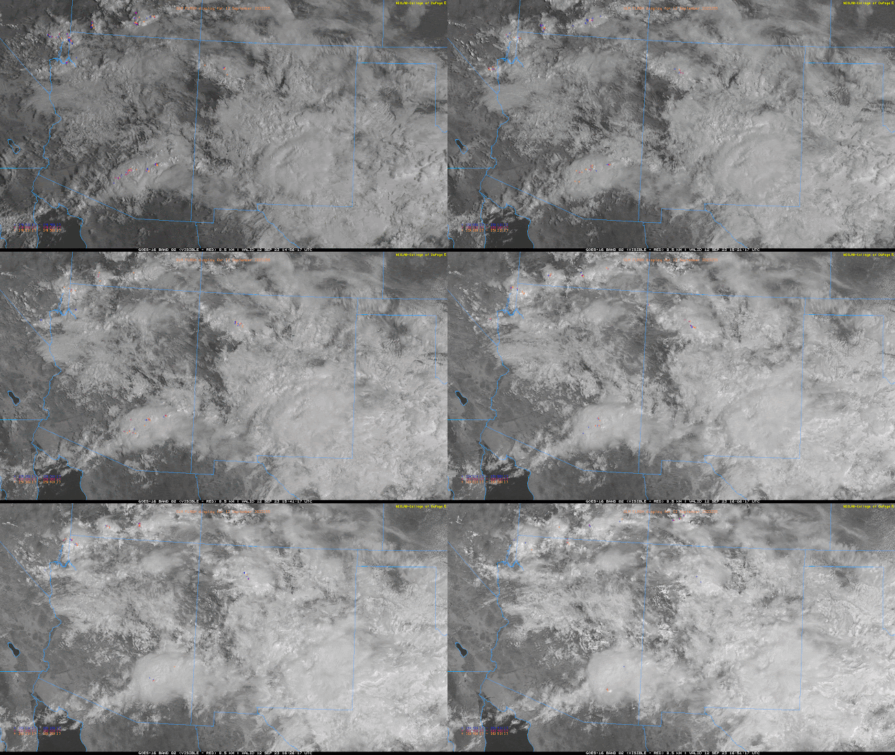
Visible imagery overlaid with GLM flashes this morning courtesy of College of Dupage.
Conditions have rapidly changed over the past 12 hours, evident from the TUS 00z and 12z soundings today.
 |
| 00z TUS sounding courtesy of the SPC. |
 |
| 12z TUS sounding courtesy of the SPC. |
Very nice sounding this morning with sufficient moisture and instability (pwat of 1.63 in, surface dew point of 62 degF, and 1024 J/kg of MUCAPE) as well as synoptic scale ascent indicated by the veering wind profile.
Today's Forecast
Synoptics
The synoptic pattern will continue to play a critical role in coverage, organization, and intensity of convection today. This morning's showers and storms were associated with positive vorticity advection and upper level divergence from an embedded shortwave. Another embedded shortwave is forecast to move through the region this afternoon and evening providing Central and Southeastern AZ with some synoptic scale ascent due to weak PVA and upper level divergence.

12z GFS 250mb divergence at 5:00 PM MST.
In addition, the 12z WRF-HRRR model soundings for Tucson and Phoenix indicating decent 30 to 40 kt shear above the LCL which will aid in organization of storms.
Moisture and Instability
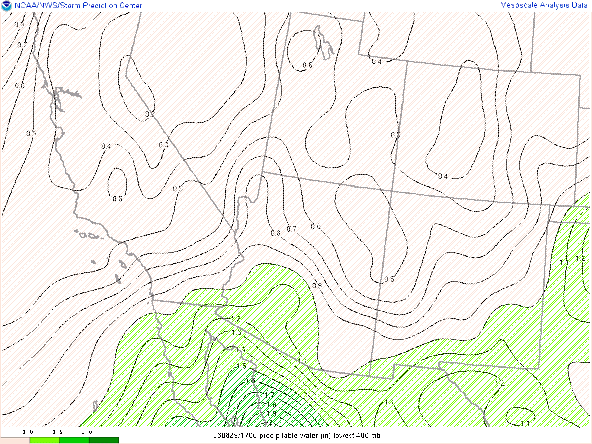
No shortage of deep moisture today with the 12z and 15z WRF-HRRR maintaining pwats between 1.25 and 1.75 in across the southern half of the state with amounts increasing westward into this afternoon.
12z WRF-HRRR total precipitable water for this afternoon at 5:00 PM MST.
Visible imagery as of 11:18 AM MST courtesy of College of Dupage.
 |
| SPC mesoanalysis of SBCAPE and CIN as of 18:00z. |

12z KTUS WRF-HRRR sounding for this evening at 6:00 PM MST. 
12z KPHX WRF-HRRR sounding for this evening at 7:00 PM MST.
What to Expect/Potential Impacts
Weak, synoptic scale ascent, strong speed shear, and sufficient thermodynamics will promote a decent chance for numerous showers and thunderstorms across Central and Southeastern Arizona this afternoon and evening. Considering the synoptic scale support, speed shear, and DCAPE, a few organized clusters are possible across the region. The 12z and 15z WRF-HRRR as well as recent runs of the raw HRRR are not very bullish with storm chances in the Tucson vicinity likely due to the delayed surface heating from the mid level cloud deck. However, with CAPE values currently in the 1500 to 2000 J/kg range across the entire region of Central and Southeastern AZ, instability is definitely not lacking. The 12z WRF-HRRR did perform very well yesterday so will stick with that solution for today's forecast. Based on the 12z guidance the majority of storm coverage will remain outside the Tucson vicinity with a few cells possible throughout the afternoon. On the other hand, skies are mostly clear in far southeastern AZ as well as in Central AZ which is where the majority of activity will occur this afternoon and evening according to current CAM solutions. The 12z WRF-HRRR forecasts two strong clusters of storms in these regions this afternoon and evening as shown below.
12z WRF-HRRR simulated maximum reflectivity for this afternoon at 3:00 PM MST.
 |
| 12z WRF-HRRR simulated maximum reflectivity for this afternoon at 5:00 PM MST. |
 |
| 12z WRF-HRRR simulated maximum reflectivity for this afternoon at 7:00 PM MST. |
 |
| 12z WRF-HRRR simulated maximum reflectivity for this afternoon at 9:00 PM MST. |
 |
| 12z WRF-HRRR simulated maximum reflectivity for this afternoon at 11:00 PM MST. |
As far as potential impacts are concerned, the SPC Day 1 Outlook has a marginal risk for severe weather in Southern and Central Arizona today.
SPC Day 1 Severe Weather Outlook.
There is a 5% chance of winds gusting to 50 mph to 60 mph. This is backed up by the 12Z HREF 4-Hour Maximum Wind Speed Probabilities indicating a 50% chance of winds exceeding 30 kts in the afternoon and evening hours in Southeastern and Central Arizona. The highest probabilities are in far Southeastern Arizona with chances exceeding 70%.
SPC Day 1 Probability of winds greater than 50 kts.
12z HREF 4-hour max wind speeds and probabilities for wind speeds greater than 30 kts.
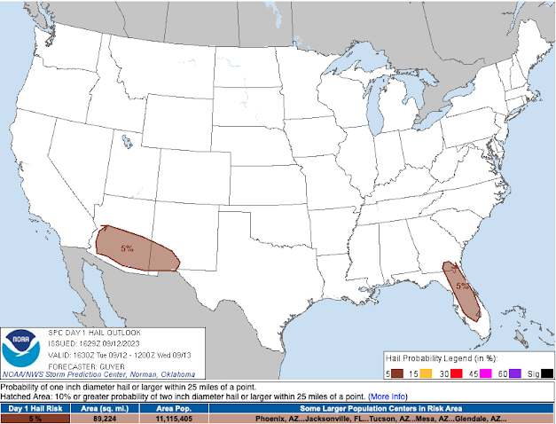
One inch diameter hail remains at a minimal 5% chance across Southern and Central Arizona as well.
SPC Day 1 Probability of hail greater than or equal to one inch.
During the late afternoon and early evening hours, the chance of thunderstorms producing localized excessive rainfall is maximized. Hence, a marginal risk of flash flooding according to the WPC Excessive Rainfall Outlook cannot be ruled out.
WPC Day 1 Excessive Rainfall Outlook.
Driving conditions will be hazardous this afternoon and evening with the I10 corridor between the AZ/NM border and Phoenix as well as the I8 corridor between Casa Grande and Gila Bend are the regions of most concern this afternoon and evening for hazardous travel conditions.


Comments
Post a Comment