September 2nd: Significant Drying for the Labor Day Weekend
Synopsis
Dry, southwest flow aloft will dry out our atmosphere this weekend leading to decreasing storm chances and mild temperatures across Arizona. Thermodynamic conditions will rapidly deteriorate across Southern Arizona, but should still remain sufficient enough for a few showers and storms across southeastern Arizona this afternoon, mainly over the higher terrain.
Current Conditions
Quite an active day across the lower Colorado River Valley yesterday with numerous showers and strong thunderstorms producing heavy rain and strong winds. On the other hand, somewhat disappointing in Central and Southeastern AZ with very minimal coverage of storms and only light rain in Tucson and Phoenix. The issue was the shortwave lifting northward moved through the region a few hours too early which prevented the area from receiving a few hours of surface heating prior to the passage of the shortwave. If that shortwave had passed through in the middle of the afternoon, it would have been a completely different day yesterday for Tucson and Phoenix.
Current SPC 500mb analysis displays the mid level anticyclone centered over the Central Plains, a closed low along the west coast, and 20 to 30 kt southerly flow over Arizona.

SPC 500mb analysis as of 16:00z this morning.
 |
| Mid level water vapor imagery this morning courtesy of College of Dupage. |
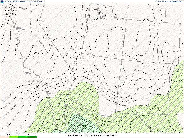
SPC mesoanalysis of total precipitable water as of 17:00z this morning.
 |
| 12z TUS sounding courtesy of the SPC. |
Today's Forecast
Synoptics
The closed low along the west coast will weaken a bit throughout the day today and mid level flow across Arizona begins to turn more southwesterly. This will allow drier air from the southwest to infiltrate the region leading to warming mid level temps and therefore more stable mid level lapse rates.
 |
| 12z GFS 500mb relative humidity for today at 5:00 PM MST. |
 |
| 12z GFS 500mb temps for today at 5:00 PM MST. |
Moisture and Thermodynamics
As mentioned above, drier southwesterly flow will begin to dry out our atmosphere starting today, but there will still be plenty of low level moisture with the WRF maintaining pwats between 1.25 and 1.50 in in Southeastern AZ into this afternoon.
12z WRF-HRRR total precipitable water at 3:00 PM MST this afternoon.
However, instability from this morning will rapidly deteriorate throughout the day today as drier air in the mid levels will warm mid level temps and develop a bit of subsidence in the mid and upper levels. The 12z KTUS WRF-HRRR sounding reflects this scenario with a strong mid level subsidence inversion developing by this afternoon.

12z KTUS WRF-HRRR sounding for this afternoon at 4:00 PM MST.
What to Expect
CAMs are not very bullish with storm coverage today with the 12z and 15z WRF-HRRR solutions only showing scattered showers and isolated thunderstorms across Southeastern AZ. As I've mentioned in previous discussions, ambiguous conditions make for a difficult forecast. Synoptics are unfavorable due to mid level drying and warming leading to some subsidence in the mid and upper levels. However there is still plenty of moisture and just enough instability for storm development today. In general, am expecting scattered showers and isolated thunderstorms across southeastern AZ, with the best chances remaining over the higher terrain. There is a chance though for a shower/thunderstorm or two in the Tucson vicinity this afternoon and evening.
Am leaning toward the 15z WRF-HRRR solution for today's forecast as the 15z has been performing best lately.
15z WRF-HRRR simulated maximum reflectivity for today at 5:00 PM MST.
 |
| 15z WRF-HRRR 2-meter temps for today at 5:00 PM MST. |
Sunday and Monday Forecast
By tomorrow, the aforementioned upper level closed low will begin to open up into a long wave trough and lift northwestward putting Arizona under west-southwesterly flow aloft. This will lead to significant drying and stabilization of our atmosphere eliminating storm chances almost completely across Arizona with only an isolated storm or two possible over the highest mountain peaks in southeastern Arizona tomorrow.
 |
| 12z GFS 500mb absolute vorticity for tomorrow at 5:00 PM MST. |
 |
| 12z GFS 500mb absolute vorticity for Monday at 5:00 PM MST. |
 |
| 12z WRF-HRRR total precipitable water for tomorrow at 5:00 PM MST. |
 |
| 12z KTUS WRF-HRRR sounding for tomorrow at 5:00 PM MST. |
 |
| 12z WRF-HRRR total precipitable water for Monday at 5:00 PM MST. |


Comments
Post a Comment