September 5th: Unseasonably Dry & Warm Through Friday
Synopsis
Southwesterly/westerly flow aloft will maintain warm, dry, and stable conditions across Arizona today. The mid level anticyclone will reconsolidate over Arizona and New Mexico starting tomorrow leading to increasing temperatures across the lower deserts.
Current Conditions
SPC 500mb analysis this morning displays the mid level anticyclone over northern Sonora with dry southwesterly flow aloft across Arizona.
 |
| SPC 500mb analysis as of 17:00z. |
This pattern will continue to reinforce dry, stable conditions across our region throughout this week.
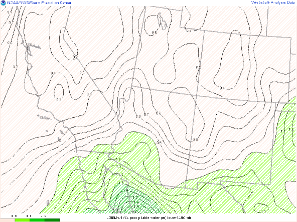
Our atmosphere is significantly moisture starved today with SPC mesoanalysis showing pwats around 0.5 in across Arizona.
 |
| SPC mesoanalysis of total precipitable water as of 17:00z. |
 |
| 12z TUS sounding courtesy of SPC. |
For perspective on how dry it is, 0.66 in is well below this 10th percentile of precipitable water for Tucson based on sounding climatology.
 |
| SPC TUS sounding climatology with current observation of pwat (black circle). |
Today through Thursday
Very, dry and stable synoptic pattern today with dry southwesterly flow aloft and a strong subsidence inversion around 700mb via the 12z TUS sounding. By tomorrow the mid level anticyclone begins to reconsolidate and strengthen over Arizona with 500mb heights slowly rising throughout this week.
 |
| 12z GFS 500mb absolute vorticity for tomorrow at 11:00 AM MST. |
 |
| 12z GFS 500mb absolute vorticity for Thursday at 11:00 AM MST. |
Interesting to note though that models are forecasting a very slight uptick in moisture for southeastern AZ on Thursday as shown below.

12z GFS total precipitable water for Thursday at 5:00 PM MST.
With increasing mid level heights over the next few days, temperatures will progressively get warmer across the lower deserts. The 12z WRF-HRRR indicates temperatures today will be the most comfortable of those to come this week with Tucson just barely missing the triple digit mark. Phoenix and the lower desert region will reach triple digits but remain near normal for today.
12z WRF-HRRR 2-meter temps for today at 3:30 PM MST.
Temperatures throughout the region will increase gradually through Thursday. Temperatures in the Tucson vicinity Wednesday and Thursday will just pass 100°F with the lower deserts extending from Yuma to Phoenix, reaching 104-107°F for Wednesday and Thursday.
12z WRF-HRRR 2-meter temps for tomorrow at 3:30 PM MST.
12z WRF-HRRR 2-meter temps for Thursday at 4:00 PM MST.
Through Thursday, excessive heat conditions will be unlikely, but models are hinting at temperatures reaching excessive heat criteria by this weekend.


Comments
Post a Comment