October 24th: Autumn Thunderstorm Action Today
Synopsis
Synoptic scale ascent combined with remnant moisture from former tropical cyclone Norma will generate numerous showers and thunderstorms across Southeastern Arizona today. The most intense and widespread activity will remain in Cochise County and into New Mexico, but a chance of showers and storms is possible in the Tucson Metro this afternoon and evening. Storms will be able to produce locally heavy rain, gusty winds, and small hail.
Current Conditions
At 8:00AM MST, visible imagery and lightning detection displayed a cluster of showers and thunderstorms moving briskly northward across far southeastern Arizona into New Mexico.
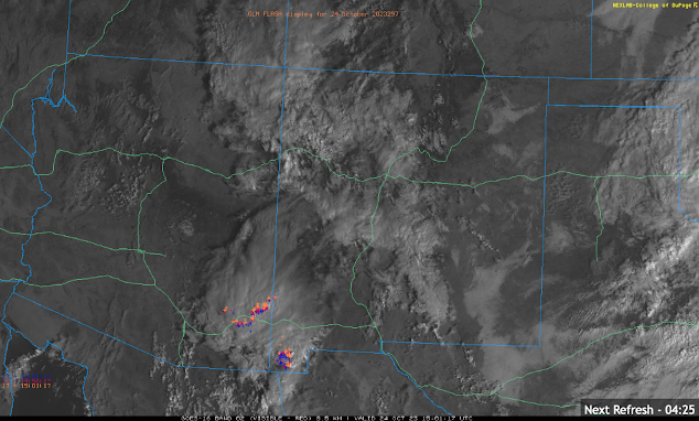 |
| Visible imagery combined with GOES GLM flashes courtesy of College of Dupage. |
This activity is associated with a region of upper level divergence indicated by this morning's SPC 300mb analysis.
SPC 300mb analysis as of 16:00z this morning.
 |
| 12z TUS sounding courtesy of the SPC. |
Today's Forecast
Synoptics
The primary driver of showers and thunderstorms today will be synoptic scale induced ascent. A deep upper level trough will move eastward throughout the day today providing cyclonic vorticity advection and upper level divergence in Southeastern AZ. This feature is also responsible for transporting the remaining moisture from former tropical cyclone Norma into the Desert Southwest.
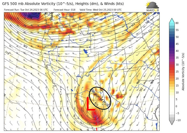
06Z GFS 500mb absolute vorticity for this afternoon at 5:00 PM MST.
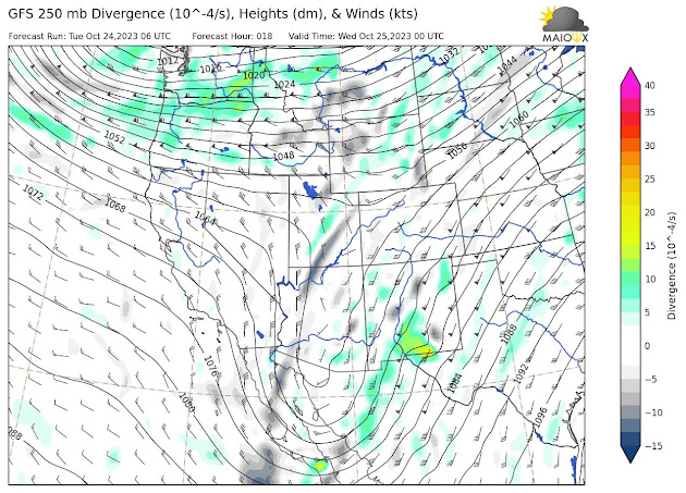 |
| 06Z GFS 250mb divergence for this afternoon at 5:00 PM MST. |
The most favorable dynamics will remain over New Mexico, but still will be plenty of synoptic scale ascent over Southeastern AZ this afternoon and evening (including Tucson).
Moisture and Instability
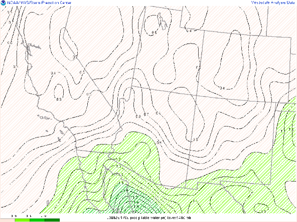
The 12z and 15z WRF-HRRR are not available today, so will use the 09Z WRF-HRRR for this analysis. As mentioned above, moisture and instability were marginal on the 12Z TUS sounding and the 09Z WRF-HRRR maintaining pwats around an inch or less throughout the day today as shown below.
09Z WRF-HRRR total precipitable water for this afternoon at 5:00 PM MST.
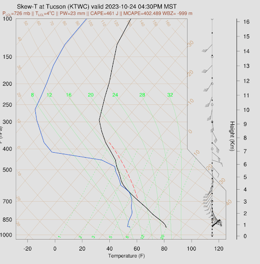
The 09Z KTUS WRF-HRRR sounding forecasting only around 400 J/kg of MUCAPE by this afternoon.
09Z KTUS WRF-HRRR sounding for this afternoon at 4:30 PM MST.
Am thinking CAPE will likely reach a bit higher than the WRF is forecasting considering the 12z TUS sounding already measured around 400 J/kg and there should be enough surface heating to increase destabilization by this afternoon.
What to Expect/Potential Impacts
With plenty of synoptic scale ascent combined with just enough moisture and buoyancy, it is looking to be quite a busy day across Southeastern AZ. As mentioned above, the most widespread, intense activity will remain east of Tucson due to better upper level support. However, CAM solutions continue to advertise showers and thunderstorms in the Tucson vicinity by this afternoon and evening. The 09Z WRF-HRRR simulated maximum reflectivity forecasting convection to impact the Tucson region by the middle of this afternoon.
 |
| 09Z WRF-HRRR simulated maximum reflectivity for this afternoon at 2:30 PM MST. |
Recent runs of the raw HRRR have been advertising activity impacting the Tucson region later in the day around sunset.
 |
| 12z HRRR simulated maximum reflectivity for this evening at 6:00 PM MST. |
Either way, CAMS are in good agreement that activity will likely impact the Tucson vicinity sometime this afternoon and evening.
As far as potential impacts are concerned, the SPC has a marginal risk of severe weather in Western Texas, Southern New Mexico and far southeastern AZ (does not include Tucson) for today with the primary threats being isolated severe grade wind gusts and hail.
SPC Day 1 Severe Weather Outlook.
12z HREF 4-hour max wind speeds and probability of wind speeds greater than 30 kts at 4:00 PM MST.
Via the 12z KTUS HRRR model sounding, the freezing level will be just above the LFC, so penny to nickel size hail is definitely a possibility in the strongest updrafts this afternoon and evening.

12z KTUS HRRR sounding for this afternoon at 4:00 PM MST.
 |
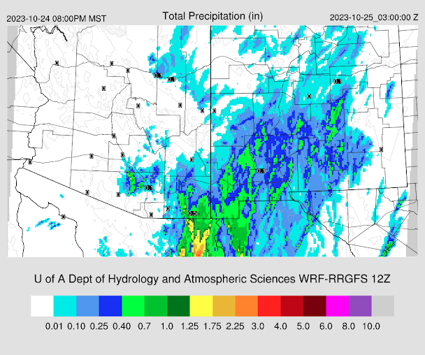
| 09z WRF-HRRR total accumulated precipitation between 2 AM MST and 8 PM MST today. |
12z WRF-RR total accumulated precipitation between 5 AM MST and 8 PM MST today.
 |
| 12z HRRR total accumulated precipitation between 5 AM MST and 8 PM MST today courtesy of College of Dupage. |
In general, expect showers and thunderstorms from Tucson eastward this afternoon and evening with the most widespread and intense activity remaining in Cochise County and in New Mexico.
The aforementioned upper level trough will lift rapidly northeastward tonight and into tomorrow morning with transitory ridging expected tomorrow afternoon shutting down storm chances almost completely with just enough remnant moisture and instability remaining for an isolated cell or two over the White Mountains and near the AZ/NM border. Otherwise, dry and tranquil weather will persist through the rest of the week and into the weekend.






Comments
Post a Comment