January 22, 2024: Strong Pacific Storm to Impact Arizona Tonight into Wednesday Morning (Part 1)
Synopsis
This is the first part of a forecast discussion regarding a strong Pacific Storm expected to impact Arizona starting this evening and persisting into Wednesday morning. The first round of moderate to heavy rain is expected to begin this evening and persist into the early morning hours tomorrow. Snow levels will remain above 7000 feet with this storm.
Current Conditions
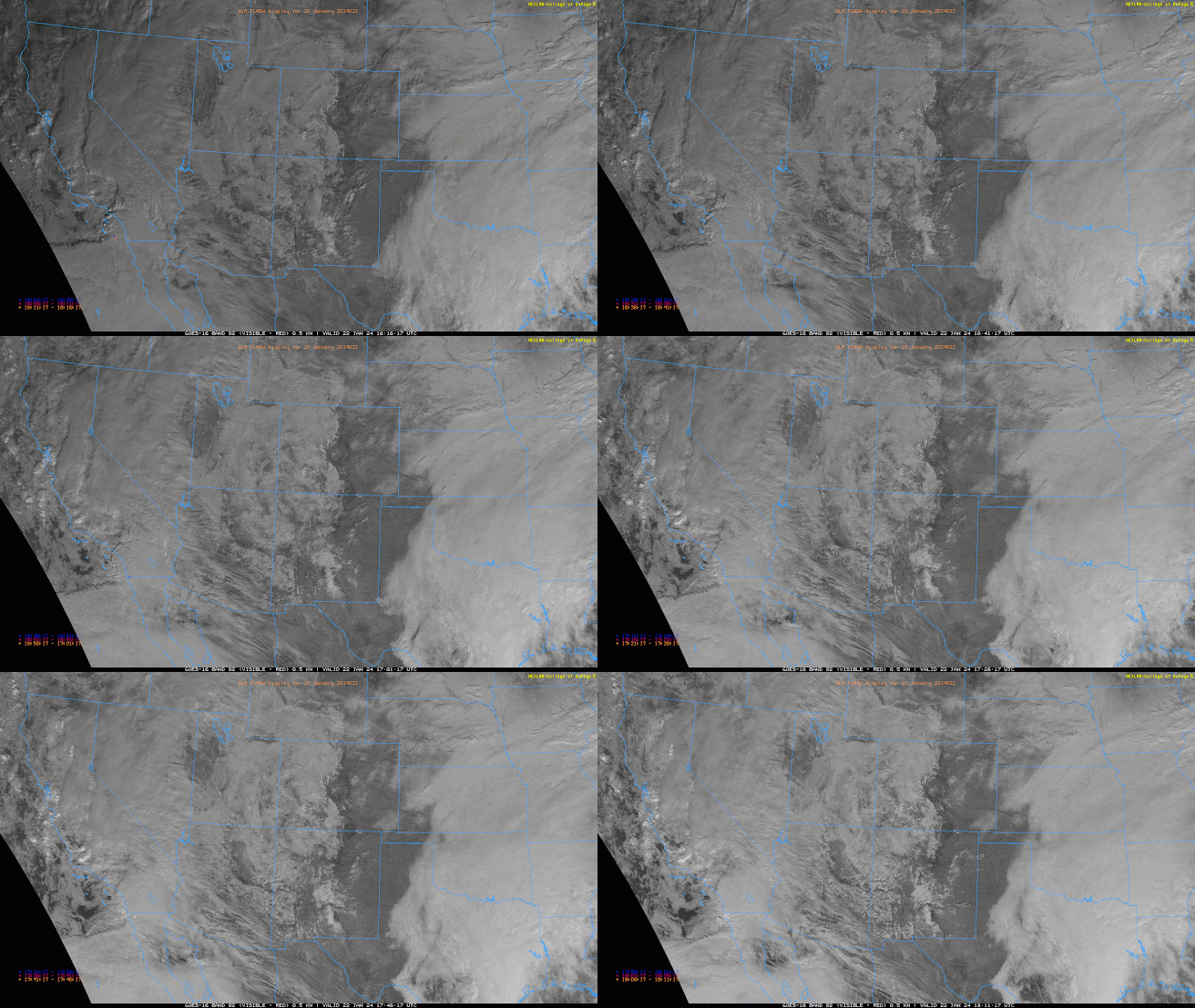
Regional visible satellite imagery overlaid with GOES GLM flashes indicates a band of heavy showers moving through far Southern California with a few sporadic lightning strikes just off the coast of San Diego this morning.
 |
| Visible satellite imagery overlaid with GLM flashes courtesy of College of Dupage. |
Current SPC 300mb analysis displays a strong jet streak just off the SoCal coast with a region of upper level divergence over far Southern California associated with the left exit region dynamics.
 |
| SPC 300mb analysis as of 18:00z. |
 |
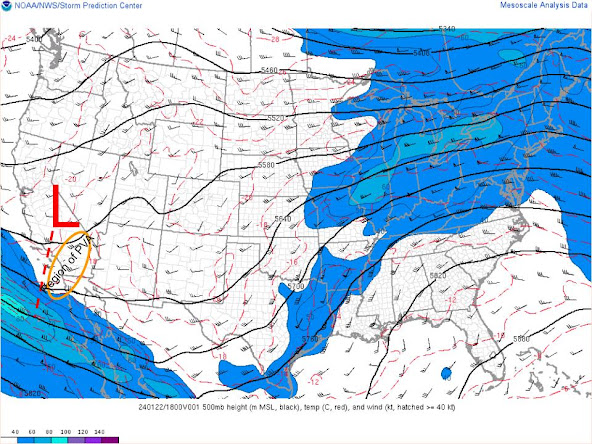
| SPC 500mb analysis as of 18:00z. |
The 12z NKX (San Diego) observed sounding displayed an impressive veering wind profile with over 200 m^2/s^2 of 0-3km SRH and 56 kts of shear between the surface and 8 km. Thermodynamics were marginal at best with only around an inch of pwat and 150 J/kg of CAPE.
 |
| 12z NKX sounding courtesy of the SPC. |
Meanwhile, partly to mostly cloudy skies across Arizona with some light rain beginning to fall over the lower Colorado River Valley. Clouds and precipitation are expected to increase from west to east throughout the late afternoon into the evening hours across the state.
Tonight through Tomorrow Morning
Synoptics
Throughout the day today the aforementioned shortwave trough and upper level jet streak off the coast of SoCal will amplify and move east into Arizona. As this occurs, Arizona will be under the influence of PVA and upper level divergence due to left exit region dynamics.
 |
| 12z GFS 500mb vorticity for tonight at 11PM MST. |
 |
| 12z GFS 300mb winds for tonight at 11PM MST. |
Synoptic scale ascent combined with modest moisture from the Pacific will lead to increasing precipitation chances throughout this evening into tomorrow morning.
What to Expect/Potential Impacts
The first round of precipitation is expected to impact Phoenix and Tucson just after sunset this evening and persisting into the early morning hours tomorrow. All members of our U AZ WRF are in good agreement regarding the timing and intensity but will be showing the 12z WRF-HRRR for this discussion.
 |
| 12z WRF-HRRR simulated reflectivity at 7:00 PM MST tonight. |
Model soundings for both Phoenix and Tucson indicating impressive veering wind profiles and nearly saturated low to mid level thermodynamic profiles by this evening. Meaning that strong synoptic scale ascent will have no problem wringing out the atmosphere of the available water vapor.
 |
| 12z KPHX WRF-HRRR sounding for this evening at 5:00 PM MST |
 |
| 12z KTUS WRF-HRRR sounding for this evening at 5:00 PM MST |
This first round of precipitation will be primarily stratiform in nature so not expecting much in the way of convection. However, with plenty of synoptic scale ascent a few rogue lightning flashes within some of the heavier rain bands is possible. Rainfall rates will increase throughout the nighttime hours into the early morning hours with CAM solutions suggesting the heaviest precipitation prior to sunrise tomorrow morning. Current CAM solutions also suggest the most intense activity will remain mainly confined to Southeastern AZ (from Tucson southward).
 |
| 12z WRF-HRRR simulated reflectivity for tomorrow at 2:00 AM MST. |
 |
| 12z WRF-HRRR 24-hour QPF from 12z today to 12z tomorrow. |


Comments
Post a Comment