Synopsis
A closed upper level low will deepen over the Desert Southwest bringing a chance for low elevation rain and mountain snow tonight through tomorrow night. Rainfall amounts will be highly variable and range from between 0.1 and 0.5 inches across the lower deserts and between 0.5 and 1.50 inches over the higher terrain. Snow levels will remain above 5000 feet with anywhere between 1 and 6 inches between 5000 and 7000 feet, and 12 to 24 inches above 7000 feet with highest amounts mainly over the mountains of Northern AZ. CAMs also suggesting some modest instability promoting a chance for a few thunderstorms across the region. Thunderstorms could produce lightning strikes, gusty winds, locally heavy rainfall, and even small hail.
Current Conditions
At 11:00AM MST, visible satellite imagery displayed an upper level low over the Northern Lower Colorado River Basin, a shallow cumulus field across SE AZ, and broken mid and high clouds across Central and Northern AZ.
 |
| Visible satellite imagery this morning courtesy of College of Dupage. |
This closed low will dominate our weather beginning today and possibly persisting into the weekend.
 |
| SPC 500mb analysis as of 18Z this morning. |
Even with increasing clouds this morning, it is still quite dry and stable across AZ with only between 0.2 and 0.4 inches of pwat, and no CAPE as indicated by SPC mesoanalysis and the 12z TUS sounding.
 |
| SPC mesoanalysis of pwat as of 18z this morning. |
 |
| 12z TUS sounding courtesy of the SPC. |
Tonight through Tomorrow Evening
Synoptics
Models are notorious for poor performance with closed lows and therefore making it a forecaster's nightmare as slight variations in the positioning of the center of the low (even on the order of less than 100km) can lead to significance differences in precipitation amounts.
Based on current deterministic guidance, the closed low is expected to deepen to around 546 dm by early tomorrow morning and become centered somewhere between the lower Colorado River Valley and Southwestern CA.
 |
| 12z ECMWF 500mb winds and heights for tomorrow at 5:00AM MST courtesy of Pivotal Weather. |
 |
| 12z GFS 500mb winds and heights for tomorrow at 5:00AM MST courtesy of Pivotal Weather. |
As the low deepens, the mid level height gradient will tighten leading to brisk southerly/southwesterly winds aloft and supplying marginal moisture transport from the Eastern Pacific. At the same time, warm advection and slowly increasing cyclonic vorticity advection will promote ascent beginning this evening and into tomorrow night.
By late tomorrow morning, the low is expected to weaken slightly, but remain relatively anchored over the AZ/CA Border. This will allow a constant supply of cyclonic vorticity across Central and Eastern AZ into the early evening hours tomorrow.
 |
| 12z GFS 500mb winds and heights for tomorrow at 11:00AM MST courtesy of Pivotal Weather. |
 |
| 12z GFS 500mb winds and heights for tomorrow at 5:00PM MST courtesy of Pivotal Weather. |
 |
| 12z GFS 500mb winds and heights for tomorrow at 11:00PM MST courtesy of Pivotal Weather. |
The combination of these synoptic scale ingredients will promote a significant chance for bands of showers with embedded thunderstorms late tonight through tomorrow evening.
Moisture and Instability
The closed low doesn't have any deep moisture source to tap into, so only marginal amounts of moisture are expected with this system. CAMs suggest only between 0.4 and 0.7 inches of pwat across the state for this evening through tomorrow evening with the highest values tomorrow as shown below.
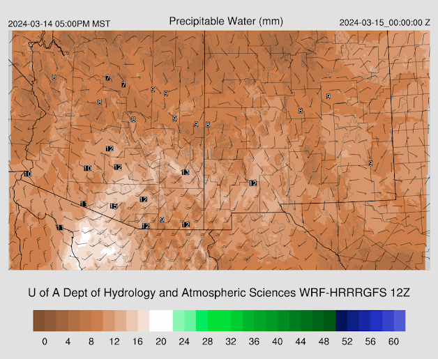 |
| 12z WRF-HRRR total precipitable water for this afternoon at 5:00PM MST. |
 |
| 12z WRF-HRRR total precipitable water for tomorrow morning at 5:00AM MST. |
 |
| 12z WRF-HRRR total precipitable water for tomorrow afternoon at 5:00PM MST. |
As the low deepens throughout the afternoon and into tomorrow morning, heights will begin to fall across the state cooling mid level temps and therefore steepening low and mid level lapse rates.
Later this evening, the 12z KTUS WRF-HRRR sounding indicating weak instability of around 200 J/kg of CAPE.
 |
| 12z KTUS WRF-HRRR sounding for tonight at 9:00PM MST. |
Also the LCL will be quite high (just below 700mb) with a relatively dry sub cloud layer and a few hundred J/kg of DCAPE. This tells me that any showers/storms that develop this evening could produce locally gusty downdraft winds and patchy blowing dust.
By late tomorrow morning into the early evening, better moisture and even colder mid level temps will provide more sufficient buoyancy across AZ with the 12z KTUS and KPHX WRF-HRRR model soundings forecasting between 300 and 600 J/kg of CAPE.
 |
| 12z KTUS WRF-HRRR sounding for tomorrow at 3:00PM MST. |
 |
| 12z KPHX WRF-HRRR sounding for tomorrow at 7:00PM MST. |
My thought is though that CAPE will be higher than the WRF-HRRR is forecasting as I have mentioned before in previous discussions that the WRF-HRRR tends to have a dry boundary layer bias, especially in SE AZ. This has been the case for the last few storm events we've had, so this will need to be monitored closely.
What to Expect
Overall, bands of moderate to locally heavy showers with embedded thunderstorms will be possible across AZ beginning later this evening and persisting into tomorrow evening due to a combination of a constant supply of cyclonic vorticity and modest buoyancy. Brisk southerly flow will also favor southern facing mountain slopes due to orographic enhancement. Below is the 12z WRF-HRRR simulated reflectivity for tonight through tomorrow evening.
 |
| 12z WRF-HRRR simulated reflectivity for tonight at 6:00PM MST. |
 |
| 12z WRF-HRRR simulated reflectivity for tonight at 9:00PM MST. |
 |
| 12z WRF-HRRR simulated reflectivity for tonight at 12:00AM MST. |
 |
| 12z WRF-HRRR simulated reflectivity for tomorrow morning at 3:00AM MST. |
 |
| 12z WRF-HRRR simulated reflectivity for tomorrow morning at 6:00AM MST. |
 |
| 12z WRF-HRRR simulated reflectivity for tomorrow morning at 9:00AM MST. |
 |
| 12z WRF-HRRR simulated reflectivity for tomorrow afternoon at 12:00PM MST. |
 |
| 12z WRF-HRRR simulated reflectivity for tomorrow afternoon at 3:00PM MST. |
 |
| 12z WRF-HRRR simulated reflectivity for tomorrow evening at 6:00PM MST. |
 |
| 12z WRF-HRRR simulated reflectivity for tomorrow night at 9:00PM MST. |
Rainfall amounts will be highly variable and will depend on trajectories of bands of showers and storms. The safe estimate is between 0.1 and 0.5 inches in the lower deserts and between 0.5 and 1.50 inches over the higher terrain with highest amounts along the southern facing slopes.
Snow levels will remain above 5000 feet with between 1 and 6 inches between 5000 and 7000 feet with upwards of 1 to 2 feet above 7000 feet with the highest accumulations especially over the mountains in Northern AZ.
As mentioned above, there is a chance for some embedded thunderstorms which could produce occasional lightning strikes, gusty winds, locally heavy rain, and even small hail.
Travel conditions will be hazardous due to the potential for brief heavy rain and gusty winds that could produce blowing dust, especially along I10 between Tucson and Phoenix as well as along I8 between the I10 junction and Yuma. Tomorrow, the morning and evening commutes will be significantly impacted as well so plan accordingly.
Will likely need to provide an early morning update tomorrow as I am anticipating some changes to CAM solutions over the next 12 hours or so. Also, am hesitant to provide any additional forecast info beyond tomorrow evening as there are still some run to run differences between synoptic and CAM solutions. Stay tuned!


Comments
Post a Comment