March 23rd, 2024: Cold, Wet, and Windy Tonight through Tomorrow Morning
Synopsis
A vort max within a broad upper level trough will impact AZ later this evening into tomorrow morning bringing breezy west winds, low elevation rain, and high elevation snow. CAMs suggest some weak instability tonight so a few thunderstorms are possible as well. Rainfall amounts will be relatively light with only a few hundredths of an inch to 0.25 inch across lower elevations and between 0.25 inch and 1 inch over the higher terrain with the highest amounts along the southwestern/western facing slopes of the mountains through tomorrow morning. Snow levels will remain above 5000 feet, so expect anywhere between a trace to 6 inches between 5000 and 7000 feet and between 6 and 12 inches above 7000 feet with highest amounts expected over the tallest peaks of the White Mountains and Mogollon Rim.
Current Conditions
At 11:50AM MST, visible satellite imagery displayed a stream of mid and high clouds over AZ and a band of showers moving into Southern California.
 |
| GOES-16 visible satellite imagery this morning courtesy of College of Dupage. |
This band of showers is associated with divergence in the left exit region of a 300mb jet streak, PVA ahead of a 500mb vort max, and surface convergence along a cold front.
 |
| SPC 300mb analysis as of 18z this morning. |
 |
| 12z GFS 500mb absolute vorticity valid for 18z this morning courtesy of Tropical Tidbits. |
 |
| WPC surface analysis as of 15z this morning. |
This Afternoon through Tomorrow Morning
Synoptics
Throughout the afternoon and into the early evening hours, a broad long wave trough will deepen over the Intermountain West and a vort max at the base of the trough will approach AZ. As this vort max approaches AZ, PVA and the associated jet exit region divergence will begin to induce increasing synoptic scale ascent from west to east across AZ late this evening into early tomorrow morning.

12z GFS 500mb absolute vorticity for tonight at 11:00PM MST courtesy of Tropical Tidbits.
 |
| 12z GFS 250mb winds at 11:00PM MST tonight courtesy of Tropical Tidbits. |
Also as the associated surface cyclone approaches this afternoon and evening, the pressure gradient will gradually tighten leading to increasing brisk southwesterly/westerly winds across the state.
12z WRF-HRRR 10-meter winds for this afternoon at 4:00PM MST.
Moisture and Instability
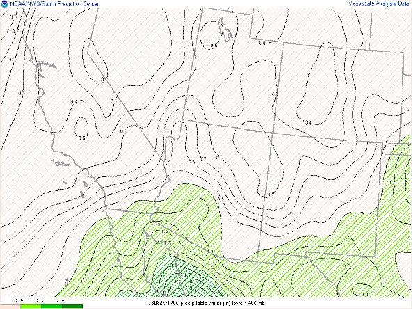
This is a relatively colder system and does not have a deeper moisture source to tap into so moisture will be marginal at best. CAMs suggest pwats between 0.50 to 0.75 inch time coincident with the maximum in synoptic scale support which should most definitely be sufficient for a brief period of moderate to locally heavy rain rates.
12z WRF-HRRR total precipitable water for late tonight at 1:00AM MST.
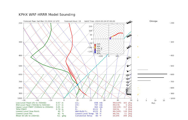
Since the synoptic scale forcing will occur during the nocturnal hours across AZ, instability will only be a function of increasing low level moisture and cooling mid level temps. As the vort max approaches, 500mb heights will rapidly fall throughout this evening leading to colder temperatures aloft and therefore steepening low and mid level lapse rates. Combine these steeper mid level lapse rates with increasing low level moisture, we should see CAPE values on the order of 100 to 200 J/kg across AZ tonight based on current HiRes guidance. Of course 100 to 200 J/kg of CAPE is not very impressive, however 12z KPHX and KTUS WRF-HRRR model soundings indicating the maximum in CAPE to be time coincident with the maximum in synoptic scale ascent.

12z KPHX WRF-HRRR model sounding for late tonight at 12:00AM MST.

12z KTUS WRF-HRRR model sounding for late tonight at 3:00AM MST.
Timing and Impacts
Overall, the combination of decent synoptic scale ascent, sufficient moisture, and marginal instability will provide moderate to locally heavy valley rain showers, a few isolated thunderstorms, and mountain snow across mainly Central and Eastern AZ late this evening through early tomorrow morning. There is good agreement among CAM solutions regarding timing and intensity for this event, so I have provided below a graphic of expected timing and impacts.
 |
| Map of timing and intensity for the storm tonight. |
This will be a fast-moving system so not expecting any threat for excessive rainfall or flash flooding. Rainfall amounts are expected to be between a few hundredths of an inch to 0.25 inch across the lower elevations and between 0.25 inch and 1 inch over the higher terrain with the highest amounts favoring southwestern/western facing mountain slopes due to orographic enhancement.
12z WRF-HRRR total precipitation forecast between 5:00AM MST this morning and 8:00AM MST tomorrow morning.
Snow levels will remain above 5000 feet with between a trace to 6 inches of snow between 5000 and 7000 feet and between 6 and 12 inches above 7000 feet with highest amounts favoring the tallest peaks of the White Mountains and Mogollon Rim.
12z WRF-HRRR total snowfall forecast between 5:00AM MST this morning and 8:00AM MST tomorrow morning.
As mentioned above, there is a chance for a few isolated thunderstorms tonight, and any thunderstorm that develops has the potential to produce sporadic lightning strikes, brief heavy rain, gusty winds, and small hail.
Tomorrow Morning through Tomorrow Evening
As the aforementioned vort max moves east into New Mexico by mid morning, AZ will still remain under broad cyclonic flow aloft. At this time, there doesn't appear to be any distinct vort max or embedded shortwave to enter AZ tomorrow to provide forcing for organized precipitation. As of now, tomorrow looks to be a scattered convective shower day as there should be just enough cyclonic vorticity and cold air aloft for a chance of scattered showers and even a rogue thunderstorm or two across the state. It will also be quite chilly as 1000mb - 500mb thickness will fall in the 540 dm range throughout the day.
Will likely need to provide a brief discussion tomorrow morning to provide additional details.


Comments
Post a Comment