April 4th, 2024: Windy, Cold, and Light Precipitation Tomorrow
Synopsis
A deep mid latitude trough will impact AZ beginning tomorrow and into early Saturday morning providing the region with gusty winds, cold temperatures, and a chance for precipitation. This system will be relatively moisture starved so mainly light precipitation is expected with the primary focus being strong winds and anomalously cold temperatures especially for this time of year. The majority of precipitation will occur over the higher terrain, but some very light rainfall accumulations are possible across the valleys. Rainfall amounts will range from a trace to 0.10 inch in the valleys and between 0.10 and 0.50 inch of SWE over the higher terrain favoring southwestern facing slopes of the mountains. Snow levels will remain above 4000 feet with between a trace to 6 inches expected and locally higher amounts possible over the highest peaks of the Mogollon Rim and White Mountains.
Current Conditions
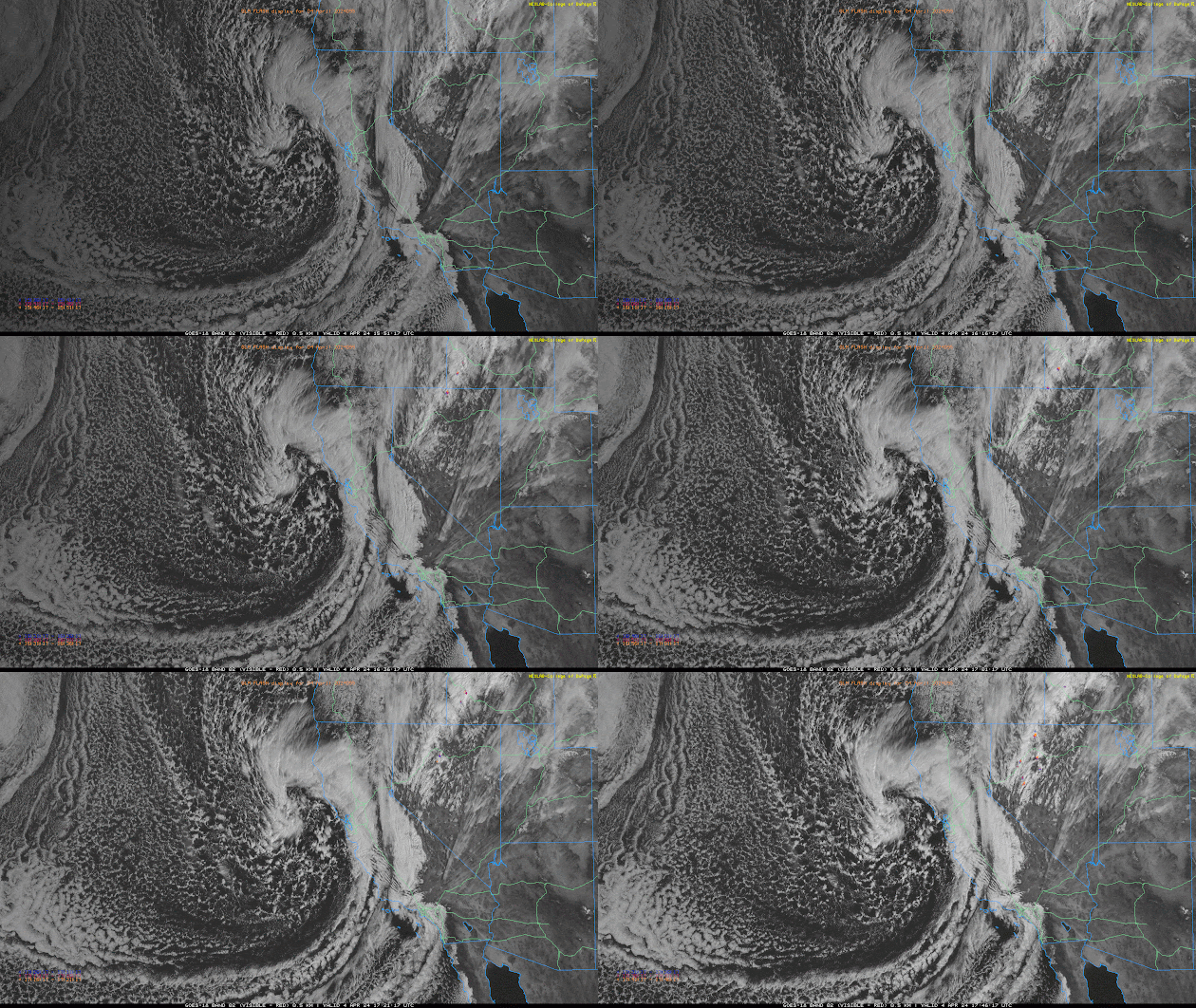
At 10:54AM MST, visible satellite imagery displayed a mid latitude cyclone along the coast of Northern California and mostly clear skies across Arizona.
 |
| GOES-18 visible imagery overlaid with GLM flashes this morning courtesy of College of Dupage. |
This midlatitude cyclone is associated with the upper level divergence within the left exit region of a polar jet streak and PVA ahead of a deepening trough off the CA coast.
 |
| 12z GFS 250mb wind speed for 11:00AM MST this morning courtesy of Tropical Tidbits. |
 |
| 12z GFS 500mb absolute vorticity for 11:00AM MST this morning courtesy of Tropical Tidbits. |
Meanwhile in our neck of the woods, very dry and stable this morning as indicated by the 12z TUS sounding measuring 0.31 in of pwat and no CAPE.
 |
| 12z TUS Sounding courtesy of the SPC. |
Expect a warm and sunny afternoon today across the state with temps in the lower deserts in the mid to upper 80s and southwest winds around 15 to 20 mph. Will be a bit breezy over the higher terrain of Northern AZ as the trough approaches with winds between 15 and 25 mph this afternoon and evening.
Tomorrow through Saturday
Synoptics
Quite similar upper level pattern compared to the Easter Storm as the polar and subtropical jets are forecast to merge once again over the Desert Southwest throughout the day today and into tomorrow acting to amplify the upper level height gradient and in response develop a strong jet streak over AZ.
 |
| 12z GFS 250mb wind speed for 5:00PM MST this afternoon courtesy of Tropical Tidbits. |
 |
| 12z GFS 250mb wind speed for tomorrow at 5:00PM MST courtesy of Tropical Tidbits. |
At the same time, the aforementioned mid level trough will continue to deepen along the CA Coast throughout the day today and into tomorrow morning. In response, a ridge downstream will amplify over the Great Plains, tightening the gradient in heights and increasing mid level flow over AZ.
 |
| 12z GFS 500mb absolute vorticity for 5:00AM MST tomorrow morning courtesy of Tropical Tidbits. |
As the mid level trough moves into the Intermountain West tomorrow, complex terrain west of the continental divide will disrupt the temperature advections and therefore begin to weaken the trough and lift the axis rapidly northeastward into the Plains.
 |
| 12z GFS 500mb absolute vorticity for 5:00PM MST tomorrow afternoon courtesy of Tropical Tidbits. |
 |
| 12z GFS 500mb absolute vorticity for 5:00AM MST Saturday morning courtesy of Tropical Tidbits. |
Even though the trough is expected to weaken, there will still be sufficient synoptic scale ascent induced by PVA ahead of the trough axis as well as the associated upper level divergence within the left exit region of the 250mb jet streak. However the primary issue with this trough, unlike with the last storm, is it will not dig southward enough to tap into deeper Pacific moisture from the southwest. In fact, based on current guidance this system will be relatively moisture starved so the synoptic scale ascent will have significantly less moisture to work with compared to last weekend.
Moisture and Instability
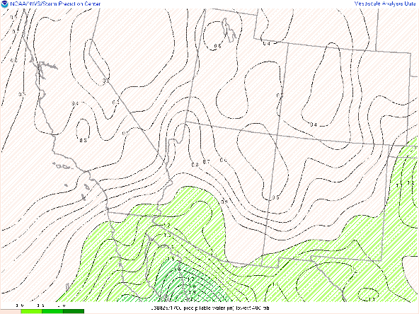
As mentioned above, this is a relatively moisture starved system with the 12z WRF-GFS indicating pwats between 0.3 and 0.5 inches across AZ tomorrow evening/early Saturday morning.
 |
| 12z WRF-GFS total precipitable water valid for tomorrow at 5:00 PM MST. |
With minimal amounts of moisture, by default buoyancy will be quite scarce with model soundings indicating pretty much no CAPE. With that being said, there won't be any threat for thunderstorms or heavy rainfall with this system. However, a rogue lightning flash or two in extreme Northwest AZ cannot be ruled out due to better synoptic scale ascent and colder mid level temps.
Precipitation Amounts
Regarding the timing of precipitation, current guidance suggests precipitation will begin early Friday evening across Western and Northern AZ (including Phoenix), and then later Friday evening and early Saturday morning across the eastern half of the state (including Tucson). Precipitation will end rapidly across AZ after sunrise as dry air invades the region from the west completely stabilizing the atmosphere on Saturday.
This system will have decent kinematics but very poor thermodynamics, so precipitation amounts will be quite light. Based on latest guidance, rainfall amounts will range between a trace to 0.10 inch in the valleys, and between 0.10 and 0.50 inch of SWE across the higher terrain with locally higher amounts possible along the southwestern facing slopes of the mountains due to orographic enhancement.
 |
| 12z WRF-GFS total rainfall forecast between 12z this morning and 18z Saturday. |
Since this is a relatively colder storm, snow levels will be much lower compared to last weekend with snow levels down to around 4000 feet. Considering this system is quite dry, there could be some evaporative cooling in the sub cloud layer to drop temps a few degrees, so I wouldn't be surprised if there were some wet flurries in some of the higher elevated valley locations above 3500 feet like Oracle or even Catalina. As far as snowfall is concerned, expect anything between a dusting to 6 inches above 4000 feet with the highest amounts mainly over the highest peaks of the Mogollon Rim and White Mountains.
 |
| 12z WRF-GFS total snowfall forecast between 12z this morning and 18z Saturday. |
Winds and Cold Temps
Besides the minimal precipitation amounts, it will be quite windy across AZ tomorrow due to the strengthening gradient in heights. As mentioned above in the synoptics section, the trough will amplify along the coast of CA into tomorrow. AZ will remain in the warm sector ahead of the trough axis tomorrow with very brisk southwesterly low and mid level flow overhead. The strongest winds will occur across mainly the eastern half of the state (including Tucson) during the afternoon with the strongest winds expected over the higher terrain. Sustained southwesterly winds between 20 and 40 knots can be expected with gusts as high as 50 knots possible.
 |
| 12z WRF-GFS 10-meter winds for tomorrow at 2:00PM MST. |
Since it will be quite dry and windy this raises some potential fire weather concerns, however considering the recent soaking rainfall and snowfall last week, sufficient soil moisture and healthy vegetation should keep any potential wild fire threat to a minimum.
Will be on the warmer side today and tomorrow due to AZ being in the warm sector ahead of the trough axis. By tomorrow night as the trough axis moves through temperatures will plummet across the state with temps in the low to mid 40s across the valleys and in the 20s and 30s over the higher terrain.
 |
| 12z WRF-GFS 2-meter temps for Saturday at 5:00AM MST. |
Will also be a chilly Saturday across AZ with high temps in the upper 50s to mid 60s across the lower deserts and in the 30s and low 40s over the higher terrain.
 |
| 12z WRF-GFS 2-meter temps for Saturday at 3:00PM MST. |
Sunday through Next Week
The trough will rapidly lift northeastward Saturday and transitory ridging will develop over AZ Sunday bringing more seasonal weather to our region. By Monday, the deterministic GFS and ECMWF as well their ensemble members are indicating some flavor of a closed low developing over the Southwest. Still quite a bit of uncertainty with this feature as it appears to be moisture starved, but will be keeping an eye on it to see if anything changes as I suspect there will be.
 |
| 12z GFS 500mb absolute vorticity for 00z Tuesday courtesy of Tropical Tidbits. |


Comments
Post a Comment