Posts

October 24th: Autumn Thunderstorm Action Today

Image
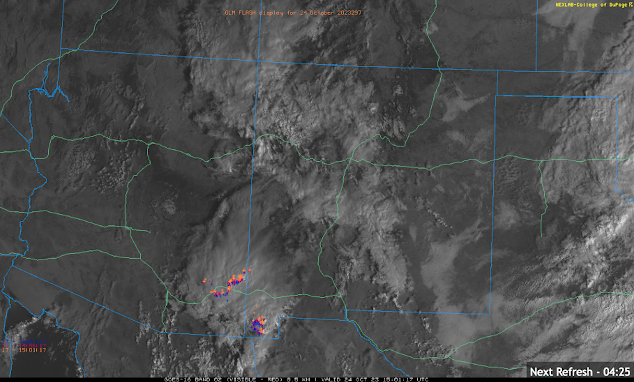
  Synopsis Synoptic scale ascent combined with remnant moisture from former tropical cyclone Norma will generate numerous showers and thunderstorms across Southeastern Arizona today. The most intense and widespread activity will remain in Cochise County and into New Mexico, but a chance of showers and storms is possible in the Tucson Metro this afternoon and evening. Storms will be able to produce locally heavy rain, gusty winds, and small hail. Current Conditions At 8:00AM MST, visible imagery and lightning detection displayed a cluster of showers and thunderstorms moving briskly northward across far southeastern Arizona into New Mexico. Visible imagery combined with GOES GLM flashes courtesy of College of Dupage. This activity is associated with a region of upper level divergence indicated by this morning's SPC 300mb analysis. SPC 300mb analysis as of 16:00z this morning. The 12z TUS sounding measured marginal moisture and instability with only 0.82 in of pwat and just ...

September 15th: Tranquil Conditions this Weekend; Most likely Dry and Cooler the Rest of September

Image
  Synopsis Very, dry and stable atmosphere indicated by the 12z sounding this morning due to westerly flow aloft. Expect dry and warm weather across the lower deserts today through Sunday. There is a chance of showers and storms near the AZ/NM Border on Sunday, but activity is expected to remain well east of Tucson and Phoenix. This will likely be the last discussion of the 2023 Monsoon Season as medium and long-range deterministic and ensemble guidance suggests mostly dry conditions through the rest of September. Current Conditions Current SPC 500mb analysis displays a shortwave trough over the Central Rockies, a high amplitude ridge over the West Coast, and zonal flow over Arizona. SPC 500mb analysis as of 18:00Z this morning. The 12z TUS sounding is really the only analysis tool needed for forecasting today with 0.66 in of pwat, a surface dew point of 46 degF, no CAPE, and a strong subsidence inversion at around 600mb.  12z TUS Soundi...

September 14th: Isolated Showers and Storms Possible in Southeastern AZ Today

Image
  Synopsis Active day yesterday afternoon with numerous showers and strong thunderstorms across Southeastern AZ. Precipitable water has plummeted overnight as westerly flow aloft today will continue to rapidly dry out our atmosphere. Still, should be just enough remnant low level moisture and some weak instability for a few isolated showers and low-topped thunderstorms mainly over the high terrain south and east of Tucson.  Current Conditions  Hope everyone enjoyed the storms the last few days as that was likely the 2023 Monsoon Season Farewell Event. Widespread showers and thunderstorms yesterday across Southeastern Arizona, mainly from Tucson eastward with some storms producing wind gusts of 40 to 50 mph and penny to nickel sized hail. Not a ton of accumulated rainfall yesterday with most locations in the Tucson metro receiving around 0.10 in or less, but Tucson International Airport received the strongest thunderstorm with 0.33 in measured...

September 13th: Monsoon Farewell Event Day 3

Image
  Synopsis Very active night/early morning in Central Arizona with rounds of numerous showers and strong thunderstorms from Phoenix eastward and this activity is still ongoing this morning. Another round of showers and strong thunderstorms is expected this afternoon and evening across Southeastern Arizona (including Tucson). SPC has southeastern AZ in a marginal risk for severe storms once again with the primary threat being strong wind gusts and up to one inch hail.  Current Conditions   Visible imagery overlaid with GLM flashes this morning displays a cluster of showers and strong thunderstorms in Central Arizona just east of the Phoenix metro. Visible imagery this morning courtesy of the College of Dupage as of 8:20 AM MST. Very active evening/night/early morning in the Phoenix vicinity with a few severe thunderstorms producing damaging winds. The strongest storms were in the southeastern Phoenix area with a couple severe storms producing wind gusts...